Private Kadifekale & Ancient Smyrna Tour
Explore the acropolis, fortress walls, Byzantine cistern, Upper Castle Mosque remains and the ancient topography of Smyrna with a private guide.
Request a Kadifekale Tour





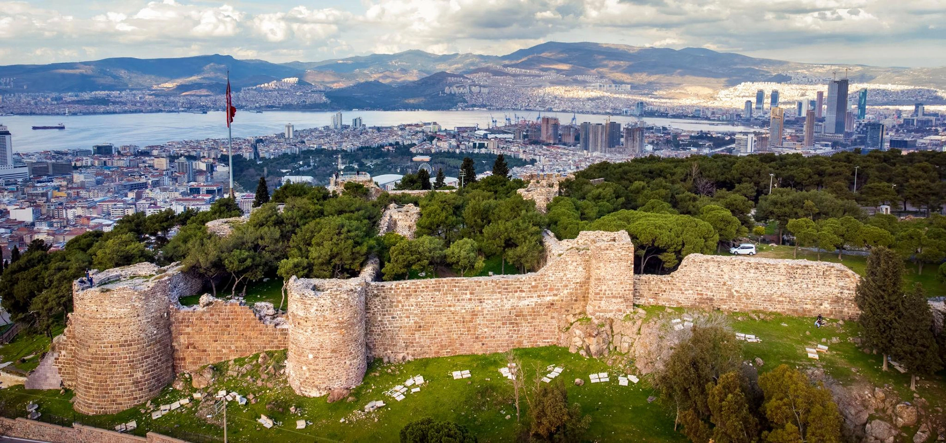
Kadifekale rises above central İzmir on the hill known in antiquity as Pagos. From its summit, the Gulf of İzmir, the dense modern city and the historic districts below spread out in one of the broadest views in the metropolitan area.
But Kadifekale is much more than a viewpoint. The hill became the acropolis of ancient Smyrna after the city expanded onto the slopes of Pagos during the Hellenistic period. Fortifications built around the late 4th and early 3rd centuries BCE formed the upper defensive centre of the new city and continued to be used, repaired and altered through Roman, Byzantine and later Turkish periods.
Inside the surviving fortress area are fragments of walls and towers, a major Byzantine cistern, remains of the Upper Castle Mosque and traces of a sacred and military landscape whose full story is still being reconstructed through archaeology. Below the hill, the Ancient Theatre of Smyrna is being excavated between Kadifekale and the Agora.
For travellers interested in archaeology, urban history and the evolution of İzmir, Kadifekale is one of the best places to understand the city vertically: acropolis above, theatre on the slope, Agora below and Kemeraltı stretching toward the old harbour zone.
Walk through the upper defensive and sacred zone of the Hellenistic city established around Mount Pagos.
See surviving sections of fortifications whose history includes Hellenistic foundations and major later repairs.
Discover one of the most impressive surviving water structures inside Kadifekale, built to support life within the fortress.
Look across the Gulf of İzmir, central districts and the route followed by ancient Smyrna from hilltop to harbour.
Essential information for visiting the ancient acropolis, fortress remains, Byzantine cistern and historic hilltop above central İzmir.
Kadifekale stands in İzmir's Konak district, immediately south of the historic city centre.
The fortress occupies Pagos Hill at approximately 186 metres above sea level.
Pagos became the acropolis, major defensive centre and an important sacred area of Hellenistic and Roman Smyrna.
The walls surrounding the acropolis were established in the late 4th to early 3rd centuries BCE.
Sections of the western fortifications, several towers and parts of the southern wall remain visible today.
A large vaulted cistern inside the fortress preserves a major part of Kadifekale's medieval water infrastructure.
The remains of the Upper Castle Mosque are associated with the early 14th-century Turkish presence in İzmir.
The enormous Theatre of Smyrna lies on the slope between Kadifekale and the Agora and remains under excavation.
The hill overlooks much of the Gulf of İzmir as well as the historic centre and inland approaches to the city.
Taxi, private vehicle or current local public transport is easier than walking the entire steep climb from the lower city.
Allow about 45–90 minutes for the fortress itself, longer if combining it with the theatre, Agora and Kemeraltı.
Morning and late afternoon are best for photography, cooler temperatures and clearer views across the city.
Kadifekale gives meaning to the ruins scattered through central İzmir because it allows you to see the ancient city as a connected landscape rather than as isolated monuments.
The first reason to visit is historical perspective. From the acropolis you can understand why the slopes of Pagos were chosen for the expanding Hellenistic city. The position controlled the Gulf, inland approaches and the urban area below, making the hill both strategically and symbolically powerful.
The second reason is archaeological continuity. Kadifekale contains Hellenistic foundations, Roman-period use, major Byzantine rebuilding, medieval water infrastructure and early Turkish remains. Few places in central İzmir present so many historical layers in one compact hilltop site.
The third reason is the relationship with the rest of Smyrna. The Ancient Theatre lies on the slope below the fortress, the Agora continues farther downhill and Kemeraltı occupies the commercial heart of the later city. Visiting these places together creates one of İzmir's strongest historical routes.
Finally, the view is exceptional. Even travellers with limited time for archaeology can appreciate Kadifekale as a place to look across modern İzmir while standing inside the surviving upper city of ancient Smyrna.
Kadifekale is located on a hill south of central Konak, above the Agora and Kemeraltı district. The ancient name of the hill was Pagos, and the summit rises to approximately 186 metres above sea level.
Its position was ideal for an acropolis. From the summit, defenders and administrators could observe the Gulf of İzmir to the west and north-west, the Yeşildere Valley inland and the broad urban territory developing across the slopes below.
Modern İzmir now surrounds the hill completely, so Kadifekale no longer feels like an isolated citadel. This contrast between ancient fortification and dense contemporary city is part of the experience.
To understand Kadifekale, it helps to begin with the earlier city of Old Smyrna near modern Bayraklı. During the Hellenistic period, Smyrna expanded and was reorganised around Mount Pagos, creating the urban centre whose monumental remains are now found around Kadifekale, the theatre and the Agora.
The fortifications surrounding the acropolis were established in the late 4th and early 3rd centuries BCE. The hill formed the upper defensive core of Smyrna and also contained important religious spaces. The walls remained useful during Roman rule, even as the city developed into one of the major urban centres of Roman Asia Minor.
During the Byzantine period, Kadifekale continued to have military value. Major wall sections were repaired or rebuilt, particularly in the medieval centuries, and water storage inside the fortress became essential for sustaining the garrison and population during times of insecurity.
Kadifekale passed into Turkish control in the 14th century. The Upper Castle Mosque belongs to this transitional period and is among the most important surviving traces of early Turkish-Islamic İzmir. Ottoman repairs followed, but the strategic role of the summit gradually declined as the city and its commercial life concentrated closer to the harbour.
By the 18th century the interior of the fortress had largely lost its earlier urban functions. Today Kadifekale survives as an archaeological and historical landscape rather than a complete enclosed castle town.
One of İzmir's best-known legends connects the relocation of Smyrna with Alexander the Great. According to the traditional story, Alexander hunted on Mount Pagos, fell asleep beneath a tree near a sanctuary of the Nemeses and dreamed that divine figures instructed him to establish a city on the hill.
The Smyrnaeans were then said to have consulted the oracle of Apollo at Claros, receiving a favourable response about settlement near Pagos. This story became an important part of the city's later historical identity and appeared in ancient literary tradition and local memory.
The archaeology and historical chronology are more nuanced. The large-scale relocation and development of the new city took place under the Successor period after Alexander, especially during the age of Antigonos and Lysimachos. For that reason, it is more accurate to describe Alexander's role as part of the foundation tradition rather than simply saying that he personally built Kadifekale.
Alexander dreams that a new city should be established around Mount Pagos.
The story continues with consultation of Apollo's oracle at Claros before the relocation.
The new Hellenistic city developed after Alexander, especially during the Successor period.
Treat the dream as a foundation legend while separating it from the archaeological chronology of the fortress.
In the ancient city, Kadifekale was not simply a castle standing above Smyrna. It was the acropolis: the elevated upper zone of the city, integrated into the fortification system and closely connected with religious and defensive functions.
The position allowed visual control across the Gulf and inland valleys while creating a powerful landmark visible from the lower city. Public buildings, residential quarters and major monuments occupied the slopes between the acropolis and the lower urban centre.
Archaeological evidence confirms sacred activity on the hill, although some older assumptions should be treated carefully. A major temple of Athena has not been securely identified on the summit. Finds including an inscribed bowl dedicated to Artemis indicate that multiple cults and ritual spaces may have existed here.
This is why Kadifekale should be read as a landscape of archaeology, not as a single monument with one date and one function.
The fortifications around Pagos were constructed in the late 4th and early 3rd centuries BCE as part of the new Hellenistic city. Their strategic purpose was clear: protect the acropolis, dominate the approaches and connect the upper stronghold with the wider defensive system surrounding Smyrna.
The walls continued in use during the Roman period. In the Late Byzantine period, damaged sections were repaired and new towers or wall segments were added, meaning that much of what visitors see today reflects a complex sequence of rebuilding rather than one untouched Hellenistic fortress.
Only part of the original circuit survives. The most visible remains are concentrated on the western side, where several towers and substantial wall sections remain standing, together with portions of the southern fortifications.
Look carefully at changes in masonry, stone size and construction technique. These variations are clues to the long life of the fortress and to the many communities that repaired it.
One of Kadifekale's most remarkable surviving structures is the large Byzantine cistern inside the fortress. Water storage was essential for any hilltop stronghold, especially during sieges or periods when access to external water sources could be cut off.
The cistern was constructed partly into the bedrock and supported by a forest of heavy piers carrying vaulted roofing. Official local heritage information describes a storage capacity of roughly 2,650 cubic metres and a structural system supported by 20 massive piers.
These numbers help explain the scale of the installation. The cistern was not a decorative feature but a piece of urban and military infrastructure capable of supporting a substantial population within the fortress.
Its surviving architecture also reminds visitors that Kadifekale was occupied and maintained long after antiquity. Restoration and presentation projects have been discussed and developed over time, so interior access can change; do not assume the cistern will always be open in the same way as the surrounding outdoor areas.
Inside the fortress are the remains of the Kadifekale Upper Castle Mosque, also referred to as the castle masjid. The site is important because it belongs to the early period of Turkish control in İzmir and helps connect the classical acropolis with the medieval history of the city.
Evliya Çelebi recorded an inscription that dated construction to 1308–1309 and named Hacı İlyas ibn Ahmed. On that basis, the mosque is often described as one of the oldest known Turkish-Islamic structures in İzmir.
For many years some foreign travellers misidentified the ruined building as a Christian chapel and even associated it with St. Polycarp. Archaeological work has instead identified the structure as an Islamic place of worship, making it a useful example of how historical interpretations can change when archaeology provides better evidence.
1308–1309 according to the inscription recorded by Evliya Çelebi.
Hacı İlyas ibn Ahmed is associated with the building in the recorded inscription.
The ruins were once interpreted by some travellers as a chapel connected with St. Polycarp.
Excavation has supported identification of the remains as a Muslim place of worship.
The Ancient Theatre of Smyrna lies below Kadifekale on the northern slope of Pagos, between the acropolis and the Agora. Its position makes it one of the most important monuments for reconstructing the layout of the ancient city.
The theatre originated in the Hellenistic period and was monumentalised during Roman rule. Major rebuilding under the emperors Trajan and Hadrian transformed it into one of the great civic entertainment buildings of Roman Smyrna.
Its estimated capacity is around 20,000 spectators. Excavations have revealed seating areas, passages, parts of the stage building, stairways and architectural decoration, but the site is still an active archaeological project rather than a fully completed visitor attraction.
As of 2026, excavation and conservation work continues, together with municipal projects intended to improve access and strengthen the historical route linking Kadifekale, the theatre, the Agora and Kemeraltı. Check current conditions before planning your visit around direct entry to the theatre excavation area.
Ancient Smyrna was arranged across a dramatic slope. At the top stood the Pagos acropolis. Below it were neighbourhoods, streets and major public monuments including the theatre. Farther down, the Agora served as one of the principal civic and commercial spaces of the Roman city.
Water systems were essential to this urban structure. Roman channels carried water across the city, while later cisterns supported the fortified summit. Some historic water passages survived into later centuries and became surrounded by local legends and devotional traditions.
Seeing Kadifekale first and then moving downhill is one of the clearest ways to understand the ancient topography. Instead of looking at ruins as separate attractions, you begin to see how the city was organised from hilltop defence to civic centre and harbour-facing commercial districts.
Several substantial towers survive along the western side of the fortress and form the most recognisable silhouette of Kadifekale.
Parts of the western and southern fortifications remain, while large portions of the original circuit have disappeared.
The great vaulted water structure survives inside the fortified area and is one of the site's most important medieval remains.
Ruins of the early Turkish mosque preserve a key layer in İzmir's medieval history.
Excavation has revealed evidence of sacred activity and different occupation phases across the acropolis.
The relationship between hill, city and gulf is itself one of the strongest surviving features of ancient Smyrna's geography.
Kadifekale is therefore not a castle where every room, gate and tower survives intact. Its value comes from the combination of monumental fragments, archaeology and topography. Visitors who arrive expecting a perfectly preserved medieval fortress may miss what makes the site historically exceptional.
Kadifekale offers one of the most revealing panoramas in İzmir. The view stretches across the Gulf of İzmir, central Konak, the dense historic city and modern districts that now fill the landscape once occupied by ancient and medieval settlement.
For history travellers, the view is not only scenic. It explains the military logic of the acropolis and helps you place the Agora, theatre and old commercial centre within the geography of Smyrna.
Late afternoon can be especially atmospheric as the light softens over the Gulf, but haze is common on hot days. Clear winter mornings and crisp spring days may provide the widest visibility.
Excellent for comfortable walking, greener surroundings and clearer views after spring weather systems.
Warm but generally manageable, especially with an early start before the strongest midday sun.
Very hot and exposed around midday. Visit early morning or toward evening and carry water.
One of the best periods for photography, city views and combining Kadifekale with a long historic-centre walk.
Cooler weather and changing light can be excellent, although rain and wind may affect exposed areas.
Quiet and often clear after rain; dress for wind on the summit and shorter daylight hours.
For most travellers, spring and autumn provide the best balance of temperature, walking comfort and photography. In summer, time of day matters more than season.
Early morning is best in hot weather. Temperatures are lower, the fortress is calmer and the air is often clearer for wide city views.
Late morning works well if you plan to continue downhill toward the Smyrna Theatre and Agora before lunch in Kemeraltı.
Late afternoon is the strongest time for atmosphere and photography, especially when the light falls across the Gulf and modern İzmir. Leave enough daylight for the descent or onward transport.
Avoid planning a rushed visit around sunset alone. Kadifekale deserves time to examine the walls, cistern area and archaeological remains before the light becomes the only focus.
The simplest option from Konak, Alsancak or Kemeraltı, especially if Kadifekale is the first stop of a historical route.
Useful if you are combining several İzmir sights, but expect steep local streets and limited flexibility close to the fortress.
City routes serve the Kadifekale area, but services and stop patterns can change; use current İzmir transport information on the day.
Possible for strong walkers, but the climb is steep and the street network is less straightforward than the short map distance suggests.
Consider going uphill by taxi or public transport, then continue downhill through the theatre and Agora toward Kemeraltı.
A practical choice for understanding the ancient city as one connected archaeological landscape rather than separate stops.
For a first visit, the most efficient plan is often to travel uphill to Kadifekale first and work your way down through the ancient city toward the Agora and Kemeraltı.
Explore on foot. Surfaces can be uneven, and archaeological areas may not follow smooth modern paths.
Stay on established visitor routes and never climb unstable masonry for photographs.
Access conditions can vary depending on conservation work, so follow current barriers and official instructions.
The ancient theatre is lower on the slope; excavation and access projects mean the most convenient approach can change.
The Agora is farther downhill and makes the natural next archaeological stop after Kadifekale.
Carry water in warm months and protect yourself from the sun; exposed areas can feel much hotter than shaded city streets.
Enough for a quick panorama, the main surviving walls and an overview of the fortress.
Best for a proper first visit with time for the fortifications, cistern area, mosque remains and photography.
Add the Smyrna Theatre area and walk part of the archaeological route downhill.
Combine Kadifekale, the theatre and the Agora with enough time to understand their relationship.
Continue through Kemeraltı, Havra Street, historic mosques and Konak for a complete ancient-to-modern İzmir route.
Allow at least one hour at the fortress and build the day around the downhill historical sequence.
This route works especially well because it follows İzmir's historical topography from high ground to harbour. If the weather is extremely hot, shorten the midday walking sections and use a taxi between Kadifekale, the theatre area and Agora.
Use angled light to bring out masonry texture, repair phases and the scale of the surviving fortifications.
Frame the ancient walls against modern İzmir to show the extraordinary continuity of occupation around Pagos.
Clear mornings can reveal long perspectives across the bay, while late afternoon gives warmer colour.
Look for changes in stonework, tower forms, arches and the surviving fabric around the cistern and mosque area.
A wide lens is useful for showing how the fortress sits above the dense urban landscape.
Do not climb walls, cross excavation barriers or stand on fragile remains to create a photograph.
Kadifekale can work well for families because the fortress visit itself does not require an entire day. Children who enjoy castles, city views and stories of ancient cities may find the site more engaging than a long museum visit.
Supervision is important around walls, drops and uneven archaeological surfaces. Do not allow children to climb ruined masonry or approach unstable edges for photographs.
Accessibility is limited by the historic terrain. Some areas may be manageable with assistance, but uneven ground, changes in level, archaeological surfaces and the steep surrounding neighbourhood make a fully step-free visit difficult. Travellers with limited mobility should arrange vehicle drop-off as close as possible and confirm current access conditions before departure.
Ancient and medieval masonry can be fragile even when it appears solid.
Excavation and restoration zones may change; never cross fences or temporary conservation boundaries.
Stones, pottery fragments and archaeological material must remain exactly where they are found.
Kadifekale is surrounded by living neighbourhoods, not an isolated archaeological park.
Carry litter out with you and avoid leaving food packaging around the fortress and viewpoint areas.
Buying from neighbourhood businesses and local producers helps tourism benefit the surrounding community.
Start at Kadifekale and work downhill toward the theatre, Agora and Kemeraltı rather than climbing late in the day.
The summit can be hot and exposed, particularly from June through September.
Expect uneven archaeological ground, stone surfaces and steep streets outside the fortress.
Restoration and excavation projects can temporarily change entry points and access to specific structures.
Public transport routes can change; check current İzmir transit information on your travel date.
Daytime makes navigation, archaeology and photography easier, especially for a first visit.
The strongest images often combine fortification walls with the vast city and Gulf below.
Kadifekale becomes much more meaningful when you continue into the lower city rather than treating it as an isolated viewpoint.
The Smyrna Theatre remains an active excavation area, so access may not resemble a finished archaeological park.
Visit İzmir lists a Saturday Pagos Producers Market in the Kadifekale area; confirm that it is operating before planning your day around it.
A monumental ancient theatre on the slope below Kadifekale, currently the focus of major archaeological excavation.
One of central İzmir's most important archaeological sites, preserving Roman civic architecture, inscriptions and urban history.
The historic commercial heart of İzmir, filled with shops, hans, mosques, food stops and streets shaped by centuries of trade.
A historic market and Jewish heritage area within Kemeraltı, best explored as part of the wider old-city route.
One of İzmir's major historic mosques, close to the former inner harbour zone and Kemeraltı.
Home to the Clock Tower and waterfront, providing a natural finish to a route descending from Kadifekale.
A useful complement for travellers who want broader context for ancient Smyrna and archaeology from across the province.
The earlier settlement of Smyrna provides an excellent chronological counterpart to the Hellenistic city around Pagos.
The essential combination for understanding the upper and lower zones of ancient Smyrna.
The strongest archaeology-focused route, following the ancient city down the slope of Pagos.
Combine ancient fortifications with the living commercial heart of historic İzmir.
A compact half-day route from hilltop panorama to Clock Tower and waterfront.
Ideal for travellers who want site context followed by a closer look at objects from İzmir's wider archaeological landscape.
Compare Bayraklı's earlier settlement with the later Hellenistic city established around Mount Pagos.
Start at Kadifekale, descend through the Agora and Kemeraltı, then finish on the modern waterfront in Alsancak.
Add synagogues, mosques, hans, food stops and waterfront monuments for a complete urban-history itinerary.
Yes, especially if you are interested in ancient Smyrna, archaeology, city history or panoramic views. It is most rewarding when combined with the Smyrna Theatre, Agora and Kemeraltı.
Kadifekale is the historic fortress and ancient acropolis on Pagos Hill above central İzmir.
The hill was known as Pagos. The fortified summit became the acropolis of the Hellenistic and Roman city of Smyrna.
The hill rises to approximately 186 metres above sea level.
The main Hellenistic fortification system around the acropolis dates to the late 4th and early 3rd centuries BCE, with extensive later repairs and additions.
The traditional foundation legend connects Alexander with the decision to establish the city around Pagos, but the major development took place under the Successor period after him. It is therefore too simple to say Alexander personally built the fortress.
According to tradition, Alexander slept on Pagos and dreamed that divine figures instructed him to establish a new city there. The Smyrnaeans later consulted the oracle of Apollo at Claros.
Yes. It formed the upper fortified and sacred zone of ancient Smyrna.
Several western towers, major wall sections, parts of the southern fortifications, a Byzantine cistern and remains of the Upper Castle Mosque survive.
It is a large medieval water-storage structure inside the fortress, built to provide a secure water supply for the fortified summit.
Official local heritage information describes a capacity of roughly 2,650 cubic metres and a roof structure supported by 20 large piers.
It is the ruined early Turkish-Islamic place of worship inside Kadifekale, associated through a recorded inscription with the year 1308–1309.
Yes. Some earlier travellers misidentified the ruins as a Christian chapel and linked them with St. Polycarp, but archaeological work supports identification as an Islamic place of worship.
It lies on the slope between Kadifekale and the Agora, below the fortress.
Current archaeological information estimates a capacity of around 20,000 spectators.
The theatre remains an active excavation and conservation project. Access conditions can change, so check current information before planning around entry.
You can see broad sections of the Gulf of İzmir, central Konak, modern city districts and the historic urban landscape below Pagos.
About 60–90 minutes is comfortable for a first visit. Allow a half day if you are adding the theatre and Agora.
Early morning is best for cooler temperatures and clearer air; late afternoon is strongest for warm light and panoramic photography.
Spring and autumn offer the most comfortable temperatures. Summer visits are best early or late in the day.
Yes, but the climb is steep and the local street network is less straightforward than it appears on a map. Many visitors prefer to go uphill by vehicle and walk downhill afterward.
Yes with supervision. The castle atmosphere and city views can be engaging, but children should stay away from unstable walls and exposed edges.
Accessibility is limited because of uneven archaeological ground, changes in level and the steep setting. Confirm current vehicle access and site conditions before visiting.
Visit İzmir lists a Saturday Pagos Producers Market in the Kadifekale area. Because market arrangements can change, verify the current schedule before travelling specifically for it.
Yes. It is one of the best combinations in İzmir: start at the acropolis, continue through the Agora and finish in Kemeraltı and Konak.
Kadifekale → Smyrna Theatre → Agora → Kemeraltı follows the ancient city naturally downhill from acropolis toward the historic commercial centre.
No. The panorama is impressive, but the real importance of Kadifekale lies in its role as the acropolis and defensive centre of ancient Smyrna.
Stopping only for the view. Spend time on the walls, cistern, mosque remains and ancient-city layout, then continue downhill to the Agora for context.
A private historical route can connect Kadifekale with the Smyrna Theatre, Agora, Kemeraltı and Konak, turning scattered monuments into one coherent story of İzmir from antiquity to the present.
Tell us whether your priority is archaeology, ancient urban planning, photography, religious heritage, Kemeraltı, food or a complete İzmir city day, and we can shape the route around your available time.
Explore the acropolis, fortress walls, Byzantine cistern, Upper Castle Mosque remains and the ancient topography of Smyrna with a private guide.
Request a Kadifekale Tour
Follow ancient Smyrna from the summit of Pagos through the theatre and Agora, then continue into the living historic streets of Kemeraltı.
Plan a Historic İzmir Day
Begin with ancient Smyrna at Kadifekale and the Agora, then move through Kemeraltı, Konak and the waterfront to see how İzmir evolved across more than two millennia.
Create a Private İzmir Route
Continue with our complete İzmir guide for archaeology, historic districts, coastal destinations, food and day trips across the province.
View İzmir Guide