Longoz Forests
Seasonally flooded woodland is the defining feature of the national park.
- Character: Forest periodically covered by water
- Water source: Streams and seasonal rainfall
- Landscape: Trees, pools, channels and wet forest floor






Hidden along the Black Sea coast of Kırklareli, close to Türkiye's border with Bulgaria, İğneada Longoz Ormanları Milli Parkı protects one of the country's most extraordinary combinations of forest and wetland habitats.
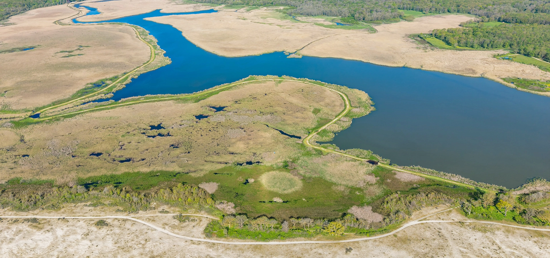
The national park covers approximately 3,155 hectares around the coastal town of İğneada. Streams descending from the Yıldız Mountains, also known as the Istranca or Strandzha Mountains, carry water and sediment toward the Black Sea. Near the coast, natural sand barriers slow this water and help create lagoons, marshes and seasonally flooded forests.
The result is a landscape unlike an ordinary woodland. During wetter periods, water spreads between the trees, transforming sections of the forest into a reflective world of trunks, branches and wetlands. Elsewhere, visitors encounter lakes, reed beds, coastal dunes, beaches and dense deciduous forest.
The protected national park extends across more than thirty square kilometres of forest and wetlands.
İğneada Longoz Forests was officially declared a national park in November 2007.
The park lies directly beside the Black Sea near Türkiye's northwestern border with Bulgaria.
Seasonal flooding creates the extraordinary longoz ecosystem for which İğneada is famous.
Essential information for planning a visit to one of the most distinctive natural landscapes in Thrace.
İğneada, Demirköy District, Kırklareli Province, northwestern Türkiye.
Open İğneada Longoz Forests on Google MapsApproximately 3,155 hectares of floodplain forest, wetlands, lakes, dunes and surrounding habitats.
2007, when previously protected areas were brought together under national park status.
Nature walks, birdwatching, wildlife observation, wetland landscapes and photography.
The unusual landscape of İğneada is the result of the meeting between mountain streams, coastal sediments, forests and the Black Sea.
Water flowing down from the Yıldız Mountains carries sediment toward the Black Sea. Over long periods, sand and alluvial material accumulated along the coast, creating natural barriers between some streams, lakes and the open sea.
When heavy seasonal rainfall increases the amount of water arriving from the mountains, these low-lying coastal areas can no longer drain immediately into the Black Sea. Water spreads backwards across the flat landscape and temporarily inundates sections of forest.
Trees growing in these periodically flooded soils have adapted to a landscape in which water is not simply beside the forest — it can become part of the forest itself.
This process produces what is known in Turkish as a longoz or subasar ormanı: a floodplain forest that becomes inundated during wetter periods.
The ecological importance of İğneada comes not from one habitat alone, but from the close relationship between floodplain forests, freshwater lakes, lagoons, marshes, reed beds, coastal dunes, streams, deciduous woodland and the Black Sea.
Within a relatively compact area, visitors encounter a remarkable mosaic of connected ecosystems.
Seasonally flooded woodland is the defining feature of the national park.
Several forest lakes and wetlands provide important habitats for aquatic plants, fish and birds.
Some lakes lie directly behind the Black Sea dunes and interact seasonally with the coastal water system.
Wetland vegetation around the lakes creates shelter and feeding habitat for birds, amphibians and insects.
The dunes separating wetlands from the Black Sea form one of İğneada's most sensitive ecological zones.
Beyond the wettest sections, the landscape continues into the rich forests of the Istranca Mountains.
Few national parks combine major wetlands and forest ecosystems with such immediate access to a wild coastline.
The connection between wetlands, forest and the Istranca Mountains allows many species to move between different habitats.
The Turkish word longoz is used for a type of floodplain or seasonally inundated forest growing on low, water-rich land.
Unlike an ordinary forest where flooding is considered an exceptional event, periodic inundation is part of the natural ecological cycle of a longoz.
Rainfall and streams increase water levels, causing low-lying parts of the forest to flood.
Water gradually recedes or moves through lakes, streams and wetland channels as conditions change.
Tree species capable of tolerating moist soils form dense woodland around the flooded areas.
Water, vegetation, insects, fish, amphibians and birds combine to create an exceptionally productive ecosystem.
The appearance of the longoz therefore changes considerably throughout the year. The famous photographs showing tree trunks reflected in standing water represent only one seasonal face of a constantly changing ecosystem.
The lakes are essential to understanding the national park. Some are coastal lagoons lying behind sand barriers, while others are freshwater lakes hidden farther inside the forest.
At approximately 266 hectares, Mert Lake is the largest of the principal lakes described in official national park information. It developed near the point where Çavuşdere reaches the coast.
Approximately 43 hectares in area, Erikli is a coastal lagoon whose connection with the Black Sea may be interrupted during the summer.
Hamam Lake covers approximately 19 hectares and lies farther inland within the forest landscape.
The roughly 10-hectare Pedina Lake is another inland freshwater environment surrounded by forest and wetland vegetation.
At approximately 5 hectares, Saka is a small lake in the southern part of the protected landscape between forest and coastal dunes.
These lakes should not be understood as isolated attractions. Water levels, streams, marshes, sand barriers and floodplain forests interact as one ecological system.
Mert Lake is one of the easiest places for visitors to begin understanding the wetland landscape of İğneada.
The lake lies close to İğneada and is surrounded by reed beds, wet forest and open water. The national park administration has established a bird observation tower beside Mert Lake, making this one of the most accessible places in the park for watching water birds and enjoying broad wetland views.
Open water and reeds create a different landscape from the enclosed flooded forest.
The observation area is particularly useful for visitors interested in water birds and migratory species.
Reflections, reeds, forest edges and changing light make Mert Lake one of the park's most rewarding photographic locations.
Its proximity to İğneada makes Mert Lake a natural first stop before exploring deeper sections of the national park.
İğneada contains an unusually rich sequence of plant communities because forest, freshwater, marsh, lagoon, dune and coastal habitats exist beside one another.
The forest contains species such as oak, oriental beech, hornbeam, ash and alder. Climbing plants are also characteristic of the humid woodland and help give parts of the longoz their dense, almost jungle-like appearance.
Trees associated with moist soils form an important part of the seasonally flooded woodland.
The surrounding deciduous forests connect the low wetlands with the wider woodland of the Istranca region.
Water-lily communities occur in suitable freshwater wetlands and add another layer to the park's aquatic vegetation.
Freshwater marshes around Hamam and Pedina lakes support distinctive aquatic plant communities including water chestnut.
Dense wetland vegetation creates important transition zones around lakes and marshes.
The Black Sea dunes support specialized vegetation adapted to wind, salt exposure and shifting sand.
The park's biodiversity is closely connected with its variety of habitats. An animal can move from dense woodland to marsh, open water, stream, dune and coastline without leaving the protected landscape.
Roe deer inhabit the wider forest landscape and are among the characteristic mammals of northern Thrace.
Otters are associated with the area's clean streams and wetland habitats, although seeing one requires considerable luck.
Dense woodland provides suitable habitat for European wildcats, one of the more elusive mammals recorded around İğneada.
Both species are part of the forest ecosystem but are much more likely to remain hidden from daytime visitors.
Wild boar occur throughout the forested landscapes of the Istranca region.
The combination of freshwater, moist forest floor and abundant vegetation creates suitable habitat for frogs, salamanders, turtles and reptiles.
Wild animals should always be observed from a distance. Feeding wildlife, approaching nests or leaving marked visitor areas can damage the fragile ecosystem and disturb animals.
İğneada is particularly important for birdlife because it lies along migration routes linking southeastern Europe with Anatolia and regions farther south.
Official conservation information records that more than 200 bird species may be observed in the İğneada area during the course of a year.
Early morning is generally the most rewarding time for birdwatching, when the park is quieter and wildlife tends to be more active.
Explore permitted forest routes and experience the changing relationship between woodland and water.
Bring binoculars and spend time around Mert Lake, reed beds and quiet wetland edges.
Flooded woodland can create striking mirror-like reflections when wind and water conditions are calm.
See how the character of the park changes between coastal lagoons and quieter inland forest lakes.
Observe the transition from woodland and wetlands to the sandy Black Sea shoreline without disturbing fragile vegetation.
Combine the forest with İğneada's beaches and experience one of Türkiye's greenest sections of Black Sea coastline.
Look for tracks, birds and signs of wildlife rather than expecting close encounters with shy forest mammals.
The national park administration and visitor centre near the entrance to İğneada can provide information about the protected landscape.
Official national park information identifies an administration and visitor centre at the entrance to İğneada.
Stopping here before exploring the park is useful because access arrangements, trail conditions and protected areas can change according to weather, water levels, conservation work and seasonal conditions.
Learn about the longoz ecosystem, wetlands and conservation importance of İğneada.
Check which routes and visitor areas are accessible before heading deeper into the forest.
Ask about observation points, walking possibilities and temporary restrictions.
Following official guidance is particularly important because many parts of the ecosystem are sensitive to disturbance.
There is no single perfect season for İğneada because the park's character changes dramatically throughout the year.
One of the most rewarding periods for greenery, wetland conditions, wild plants and active birdlife. Wetter conditions may also create the classic flooded-forest scenery.
Warm weather makes it easy to combine the forest with İğneada's Black Sea coast, although some wetland areas may contain less standing water.
Deciduous trees turn yellow, copper and brown, making this an excellent season for landscape and forest photography.
Rainfall and higher water levels can transform the landscape, although trails may become muddy and access conditions more difficult.
The national park surrounds the coastal town of İğneada in the Demirköy district of Kırklareli Province.
The national park is much larger than a single viewpoint. How long you need depends on whether you want only an introduction or a broader exploration of the lakes, forest and Black Sea coast.
Allow around 1–2 hours for the visitor centre, Mert Lake area and a short introduction to the wetland landscape.
Allow 3–4 hours for Mert Lake, forest walking, birdwatching and several photography stops.
A full day gives you time to explore different parts of the park and combine the wetlands with İğneada's Black Sea coast.
Staying in İğneada allows you to experience quieter early mornings, evening light and more than one section of the surrounding landscape.
Forest tracks can become muddy, slippery or waterlogged, particularly after rain.
The appearance and accessibility of the flooded forest changes according to rainfall and season.
İğneada is an excellent birdwatching area, particularly around wetlands and reed beds.
Morning visits usually offer quieter conditions, softer light and better opportunities to observe wildlife.
Wetlands, dunes and forest-floor vegetation can be extremely sensitive to trampling.
Wild animals should remain wild and should always be viewed from a respectful distance.
Avoid driving or walking across sensitive dune vegetation outside designated access areas.
Leave the forest exactly as you found it and avoid disposable plastics whenever possible.
İğneada is one of the most atmospheric natural photography destinations in European Türkiye. Its greatest strength is the variety of landscapes concentrated within a small region.
Look for calm water and vertical tree trunks to create symmetrical reflections inside the longoz.
Open water, reeds and the forest edge are particularly attractive in early morning or late afternoon light.
Golden and copper foliage can create beautiful colour contrasts with dark water and tree trunks.
Use a long lens and maintain enough distance that birds continue their natural behaviour without disturbance.
Cloudy weather, waves, dunes and dark forest can create dramatic coastal compositions.
Wet leaves, saturated colours and reflected light can make rainy conditions surprisingly rewarding.
İğneada can form the centre of a much broader journey through northern Kırklareli, combining forests, caves, Black Sea villages and Byzantine heritage.
Explore the province's Ottoman monuments, archaeological heritage, forests, coastal villages, local foods and natural attractions.
Stay in the small Black Sea town beside the national park and combine the wetlands with beaches, seafood and coastal scenery.
Explore the coastline north of İğneada and discover the historic lighthouse landscape overlooking the Black Sea.
Travel inland into the Istranca Mountains to discover one of Thrace's best-known cave systems and an important underground wildlife habitat.
Visit the remarkable Byzantine rock-cut monastery near the Black Sea settlement of Kıyıköy.
The forested district centre provides access to the Istranca Mountains and several historical and natural attractions of northern Kırklareli.
Discover the historic Ottoman ironworking site near Demirköy, associated with the region's rich deposits of iron and extensive forests.
Continue through northern Thrace's vast forest landscape, with opportunities for nature walks, scenic drives and rural exploration.
It is a protected national park in Kırklareli containing seasonally flooded forests, lakes, lagoons, marshes, streams, coastal dunes, deciduous woodland and Black Sea shoreline.
The park surrounds the town of İğneada in Demirköy District, Kırklareli Province, close to Türkiye's border with Bulgaria and directly beside the Black Sea.
Official national park information gives its area as approximately 3,155 hectares.
İğneada Longoz Ormanları was officially declared a national park in November 2007.
Longoz refers to a floodplain or seasonally flooded forest where periodic inundation forms a natural part of the ecosystem.
Streams descending from the Istranca Mountains carry water toward the Black Sea. Coastal sand barriers and the flat terrain slow drainage, allowing water to spread across low-lying forest during wetter periods.
No. Flooding is seasonal and depends heavily on rainfall, groundwater and changing lake levels. Conditions can vary considerably throughout the year.
The best-known lakes include Mert, Erikli, Saka, Hamam and Pedina. Official descriptions of the wider national park landscape also identify additional wetland areas in its southern sector.
Mert Lake is the largest of the five principal lakes described in detailed official park information, covering approximately 266 hectares.
Yes. İğneada is one of the most interesting birdwatching destinations in Thrace, and an observation tower is located beside Mert Lake.
Official conservation information states that more than 200 bird species can be observed in the area at different times during the year.
Wildlife recorded in the region includes roe deer, wild boar, foxes, badgers, wildcats, otters, numerous bird species, amphibians, reptiles, fish and insects.
Spring is excellent for green scenery, birdlife and wetter forest conditions, while autumn is particularly attractive for colourful woodland photography. Every season offers a different experience.
The strongest flooding generally follows wetter periods, often during winter and spring, but there is no guaranteed date because conditions depend on rainfall and natural water levels.
Nature walking is one of the principal ways to experience the area. Visitors should use permitted routes and respect temporary restrictions caused by flooding, conservation work or seasonal conditions.
Yes. Official national park information identifies an administration and visitor centre near the entrance to İğneada where visitors can obtain information about the area.
Admission and vehicle fees may apply. Because national park tariffs can change, check the current official information before travelling rather than relying on older published prices.
Official national park information gives a road distance of approximately 230 km from central Istanbul.
Allow at least half a day for a meaningful introduction. A full day or overnight stay is better if you want to combine the wetlands, forest, birdwatching and Black Sea coast.
Yes, especially for travelers interested in unusual ecosystems, forests, wetlands, birdwatching, nature photography and quieter destinations beyond Türkiye's best-known tourist routes.
Nearby attractions include the Black Sea coast, Limanköy, Dupnisa Cave, Demirköy, the Istranca Mountains and the historic settlement of Kıyıköy with its rock-cut Aya Nikola Monastery.
A floodplain forest is particularly vulnerable because water connects almost every part of the ecosystem. Pollution or disturbance in one location can affect lakes, marshes, plants and wildlife elsewhere.
Take all rubbish away with you and avoid leaving food, plastics or cigarette ends anywhere in the park.
Never chase animals, approach nests or play loud sounds to attract birds.
Avoid entering reed beds, marshes or flooded areas outside authorized routes.
Stay away from sensitive dune vegetation and never drive vehicles across undesignated coastal areas.
Many wetland and coastal species occur in highly specialized habitats and should remain untouched.
Temporary restrictions may protect wildlife, reduce fire risk or keep visitors away from flooded and unsafe areas.
İğneada can be included in a tailor-made journey through the forests, Black Sea coast, villages and historic landscapes of Kırklareli and Thrace.
Tell us what interests you most and we can design a private route focused on nature, photography, birdwatching, Black Sea landscapes and the cultural heritage of Kırklareli.
Ask us about a tailor-made excursion combining İğneada Longoz Forests, Mert Lake, Black Sea scenery and other natural highlights of northern Kırklareli.
Request a Custom Tour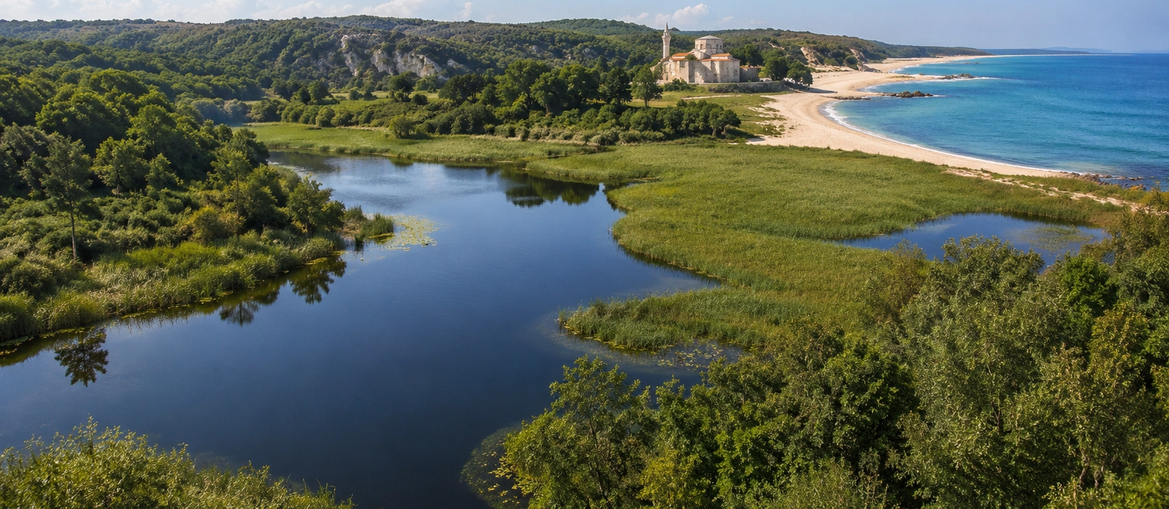
Continue planning your journey with our Kırklareli guide covering Ottoman monuments, Byzantine heritage, forests, caves, Black Sea villages and regional food.
View Kırklareli GuideNorthern Thrace is ideal for travelers who want to combine quiet natural landscapes with historic towns and monuments away from Türkiye's busiest sightseeing routes.
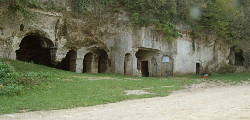
Combine the wetlands and forests of İğneada with the dramatic Black Sea setting and rock-cut Byzantine heritage of Kıyıköy.
Discover Kıyıköy
Create a private itinerary linking Istanbul with Kırklareli, İğneada, the Istranca Mountains, Kıyıköy and other remarkable destinations across Thrace.
Plan Your Route