Private Karabel Bronze Age Experience
Explore the Karabel Pass with a private guide and uncover the story of Tarkasnawa, the kingdom of Mira, Hieroglyphic Luwian and Late Bronze Age western Anatolia.
Request a Private Experience





On a rocky mountainside above the historic route between Kemalpaşa and Torbalı, a solitary warrior has looked across the landscape of western Anatolia for more than three thousand years.
This is the Karabel Rock Relief, one of the most remarkable surviving monuments of Late Bronze Age western Türkiye. Commonly described as a Hittite rock relief, the monument is more precisely connected with the Luwian-speaking kingdom of Mira, one of the powerful western Anatolian states operating within the political world dominated by the Hittite Empire.
The figure was once mysterious. Ancient Greek historian Herodotus believed a rock-cut warrior in this landscape represented the legendary Egyptian conqueror Sesostris. Modern scholarship, however, transformed our understanding of the monument when its Hieroglyphic Luwian inscription was successfully read and connected with Tarkasnawa, King of Mira.
Karabel therefore brings together archaeology, ancient geography, lost kingdoms, royal propaganda and the history of archaeological discovery in a single extraordinary place.
The surviving relief is identified with Tarkasnawa, ruler of the Late Bronze Age kingdom of Mira.
An inscription beside the ruler played a decisive role in revealing the monument's true identity.
The ancient historian associated a rock relief in this landscape with the Egyptian conqueror Sesostris.
Karabel provides rare monumental evidence for the political geography of the Aegean world during the 13th century BCE.
Essential information about one of western Anatolia's most important surviving Late Bronze Age rock monuments.
Karabel Pass on the Kemalpaşa–Torbalı road in İzmir Province, western Türkiye.
Open on Google MapsLate Bronze Age, generally dated to the 13th century BCE.
The inscription identifies the figure as Tarkasnawa, King of Mira.
The monument bears an inscription written in Hieroglyphic Luwian.
The surviving relief is approximately 2.5 meters high and 1.5 meters wide.
Linking the kingdom of Mira with the Late Bronze Age political geography of western Anatolia.
Karabel is one of the rare places where the political landscape of Late Bronze Age western Anatolia survives in monumental form.
The Late Bronze Age was a period of powerful kingdoms, international diplomacy, warfare and long-distance exchange extending from Egypt and Mesopotamia to Anatolia and the Aegean.
In central Anatolia, the Hittite Empire was one of the great powers of the ancient Near East.
Western Anatolia, however, was not simply an empty frontier of that empire. It contained its own kingdoms, dynasties and political centers. Among the most important was Mira, a kingdom that appears repeatedly in Hittite diplomatic and historical documents.
The Karabel relief gives this otherwise text-heavy political world a human face.
Carved directly into the mountain, the figure of Tarkasnawa presented royal authority to people moving through an important natural corridor. More than three thousand years later, the monument remains one of the most evocative connections between the archaeological landscape around modern İzmir and the political world described in Late Bronze Age Anatolian texts.
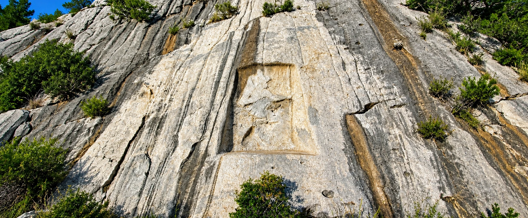
The Karabel monument is a rock-cut bas-relief carved into a natural cliff at Karabel Pass southeast of Kemalpaşa.
The surviving figure, conventionally known to archaeologists as Karabel A, depicts an armed male ruler shown in profile within a recessed rectangular area of rock.
The figure wears clothing and equipment characteristic of Late Bronze Age Anatolian elite imagery and carries weapons emphasizing his status as a ruler and warrior.
Beside the figure is a short inscription written with Anatolian hieroglyphs used for the Luwian language.
It was this inscription that eventually allowed scholars to move beyond older speculation and identify the ruler represented at Karabel.
The figure was carved directly into the natural cliff rather than created as a freestanding statue.
The monument presents an armed elite male figure traditionally interpreted as a ruler.
Hieroglyphic signs beside the figure preserve the name and royal identity of Tarkasnawa.
Its location beside an important route was probably central to the monument's meaning.
To understand Karabel, it is necessary to imagine western Anatolia before the famous Greek cities of the Aegean reached their classical form.
During the second millennium BCE, political geography was very different from the world later known to Greeks and Romans.
The Hittite kingdom centered on Hattusa expanded into an empire whose diplomatic relationships reached deep into western Anatolia.
Hittite texts refer to western regions and kingdoms including Arzawa, Mira, the Seha River Land and Wilusa, creating a complex map of states that negotiated, fought and formed alliances with the Hittite Great Kings.
Karabel belongs to this world.
Its ruler was not simply an anonymous soldier stationed at the edge of the Hittite Empire. He belonged to a royal dynasty governing one of western Anatolia's most important political territories.
The relief is generally placed within the later phase of the Late Bronze Age.
Central Anatolia was dominated by an imperial court based at Hattusa.
Mira formed part of a wider political landscape of powerful western Anatolian states.
The region stood close to routes linking inland Anatolia with the Aegean coast.
Hittite documents preserve treaties, political negotiations and conflicts involving western rulers.
The balance of power between the Hittite court and western Anatolian kingdoms changed repeatedly.
One of Karabel's greatest contributions to archaeology is its connection with the ancient kingdom of Mira.
Mira appears in written sources from the Hittite capital as one of the major political entities of western Anatolia.
Its history was closely linked with the wider group of western lands conventionally associated with Arzawa.
Over time, the rulers of Mira became increasingly important within the political network connecting western Anatolia and the Hittite imperial court.
The reading of the Karabel inscription gave scholars a rare geographical anchor for these written sources because it placed a king explicitly identifying himself with Mira within the landscape near modern İzmir.
That discovery greatly influenced attempts to reconstruct the borders and political geography of western Anatolia during the Late Bronze Age.
A major Late Bronze Age kingdom in western Anatolia known from Hittite written sources.
Mira developed within the broader political landscape traditionally associated with the Arzawa lands.
Its rulers participated in political relationships with the Hittite Great Kings.
Karabel provides important geographical evidence for locating Mira within the region.
For generations, the identity of the Karabel figure remained uncertain.
The breakthrough came when the hieroglyphic inscription was reexamined by leading specialist J. D. Hawkins.
Hawkins recognized the royal name Tarkasnawa and demonstrated that the inscription identifies him as King of Mira.
The inscription also places Tarkasnawa within a royal dynasty by referring to his father and grandfather, themselves rulers of Mira.
Tarkasnawa was already known to scholarship through seals connected with the Hittite capital at Boğazköy–Hattusa. The ability to connect those records with the ruler carved at Karabel transformed the monument into an exceptionally valuable piece of historical evidence.
The personal name read in the hieroglyphic inscription accompanying the relief.
The inscription explicitly connects Tarkasnawa with the western Anatolian kingdom of Mira.
The text situates Tarkasnawa within several generations of rulers.
Evidence from seal impressions provides additional documentation for Tarkasnawa and his royal status.
The inscription beside the ruler is small compared with the monumental figure, but historically it is one of the most important elements of Karabel.
It is written using Anatolian hieroglyphs, a writing system most commonly associated with texts in the Luwian language.
The signs are positioned beside the upper part of the figure and identify Tarkasnawa and his connection with Mira.
Their successful interpretation provided a crucial link between the monument and rulers known from other Late Bronze Age sources.
For archaeologists reconstructing western Anatolia, the inscription transformed Karabel from an impressive but anonymous warrior image into a monument connected with a specific kingdom and royal dynasty.
The inscription uses the indigenous Anatolian hieroglyphic writing tradition.
Hieroglyphic Luwian became one of the most important written languages for understanding ancient Anatolia.
The reading of Tarkasnawa's name provided the decisive clue to the monument's identity.
The text connects the ruler with Mira and therefore with the historical geography of western Anatolia.
References to earlier generations emphasize continuity of royal authority.
A short inscription ultimately helped scholars reconsider the map of Late Bronze Age western Anatolia.
The surviving ruler stands in profile within a carefully prepared recessed panel.
He advances with one leg forward, creating the impression of controlled movement rather than a static portrait.
Weapons and clothing establish his status as an elite warrior-ruler.
A bow is carried over the shoulder, while another weapon is held or worn as part of the ruler's martial equipment.
The visual language belongs to a wider Anatolian tradition in which rulers and deities could be represented through recognizable clothing, weapons, headgear and hieroglyphic labels.
At Karabel, the combination of image and inscription turns the cliff itself into a statement of political presence.
The ruler is represented from the side according to established Anatolian artistic conventions.
Weapons emphasize authority, status and the martial identity of the king.
Dress and headgear connect the figure with the elite visual culture of Late Bronze Age Anatolia.
At approximately 2.5 meters high, the carved panel was designed to dominate its immediate setting.
Karabel is frequently called the Karabel Hittite Rock Relief, and this name remains widely used in travel literature and official tourism material.
The historical reality is more nuanced.
The ruler represented at Karabel was Tarkasnawa of Mira, not a Great King ruling directly from the Hittite capital at Hattusa.
Mira was a western Anatolian kingdom deeply connected with the Hittite imperial political system, while the inscription at Karabel belongs to the Hieroglyphic Luwian writing tradition.
It is therefore useful to think of Karabel as a Late Bronze Age Anatolian or Hittite-Luwian monument associated with the kingdom of Mira.
Karabel possesses an unusual distinction: a rock monument in this general landscape was apparently known to one of antiquity's most famous historians.
In the fifth century BCE, Herodotus described rock-cut figures in western Anatolia that he associated with a legendary Egyptian conqueror whom he called Sesostris.
Herodotus believed the figure represented an Egyptian king who had campaigned across distant lands and commemorated his victories by carving monuments.
For centuries, this ancient testimony strongly influenced how travelers and early scholars interpreted Karabel.
The identification was eventually rejected as knowledge of Anatolian Bronze Age civilizations improved.
Modern study of the inscription demonstrated that the surviving Karabel relief belongs not to an Egyptian pharaoh but to the indigenous political landscape of Late Bronze Age western Anatolia.
Herodotus wrote centuries after the Karabel relief itself had been carved.
Herodotus associated western Anatolian rock figures with a legendary Egyptian conqueror.
The visual appearance of the monument led to an interpretation that modern archaeology no longer accepts.
The account nevertheless demonstrates the enduring visibility and mystery of monumental rock carvings in this landscape.
European travelers and scholars encountered Karabel during the nineteenth century, when knowledge of the Hittites and the Bronze Age civilizations of Anatolia was still extremely limited.
Because Herodotus had described an apparently Egyptian-looking monument in western Anatolia, early investigators naturally debated whether Karabel might be his monument of Sesostris.
As discoveries elsewhere in Anatolia accumulated, researchers began recognizing similarities between Karabel and monuments that would eventually be understood as belonging to the Hittite and Luwian cultural world.
The monument consequently played an important role in the early development of Hittite studies.
Its story illustrates a fundamental principle of archaeology: interpretations change when new evidence, new languages and new methods become available.
Drawings and descriptions introduced Karabel to a wider scholarly audience.
Researchers compared the monument with Egyptian, Anatolian and Near Eastern artistic traditions.
Karabel became important during the gradual recognition of an ancient civilization centered in Anatolia.
The decipherment of its royal name eventually established a far more precise historical identity.
The modern interpretation of Karabel changed dramatically through the work of specialist J. D. Hawkins.
By comparing the hieroglyphic signs at Karabel with inscriptions, seals and the increasingly well-understood corpus of Hieroglyphic Luwian, Hawkins recognized the name of Tarkasnawa.
The reading was established in the late 1990s and published in a major study of Tarkasnawa, the Karabel monument and related sealings from Boğazköy.
This identification connected an image in the mountains of western Türkiye with a named Bronze Age ruler known from the documentary world of Hattusa.
It remains one of the most striking examples of how epigraphy can transform the historical meaning of an archaeological monument.
The single ruler visible today represents only part of the archaeological complex once documented at Karabel.
Researchers recorded additional monuments in the surrounding area, conventionally labeled Karabel B, C1 and C2.
Karabel B included another ruler relief, while C1 and C2 were inscribed stone monuments.
The surviving principal figure became known as Karabel A.
Much of the associated monument group disappeared or was destroyed during changes to the road and landscape in the twentieth century.
Old drawings, photographs, casts and archaeological descriptions are therefore extremely important because they preserve information about features no longer visible on the ground.
The principal ruler relief that survives on the cliff today.
A second ruler relief once documented within the wider Karabel landscape.
One of the additional hieroglyphic inscriptions formerly recorded near the pass.
Another inscribed monument known through earlier archaeological documentation.
Karabel's position was almost certainly meaningful.
Mountain passes compress movement into narrow natural corridors. Travelers, armies, herders, messengers and merchants often have little choice but to use routes dictated by the terrain.
A royal image carved beside such a route could therefore communicate authority to a remarkably broad audience.
The monument may have marked territorial control, celebrated royal power, emphasized a political frontier or simply announced the presence of the ruling dynasty within an important landscape.
Scholars continue to debate the precise political function of the relief, and no surviving text explains exactly why Tarkasnawa chose this location.
What is clear is that the relationship between the monument and the pass is fundamental to understanding Karabel.
The surrounding mountains channel movement through a limited number of practical routes.
A monumental ruler image could communicate authority to people moving through the landscape.
Some interpretations connect Karabel with territorial organization or the limits of royal authority.
The monument transformed a natural cliff into a permanent representation of kingship.
Late Bronze Age political relationships rarely fit simple modern categories such as independent nation or directly governed province.
Mira maintained its own rulers and royal dynasty while also participating in the diplomatic system dominated by the Hittite Great Kings.
At different moments, western Anatolian rulers could be allies, treaty partners, dependents or opponents of Hattusa.
This makes Tarkasnawa particularly interesting.
His image at Karabel communicates unmistakable local kingship, while seals and written evidence connect his dynasty with the wider political world of the Hittite Empire.
Karabel therefore represents both regional identity and participation in a much larger Late Bronze Age international system.
Tarkasnawa lived during an era when the eastern Mediterranean was connected through diplomacy, trade, migration and warfare.
To the east stood the Hittite imperial capital at Hattusa.
Farther west lay the Aegean world associated archaeologically with the Mycenaean palatial civilizations.
Hittite texts also refer to a western power called Ahhiyawa, widely discussed by scholars in relation to the Mycenaean Aegean.
To the northwest, the kingdom known in Hittite documents as Wilusa has played an important role in discussions surrounding Bronze Age Troy.
Karabel therefore belongs to a historical landscape extending far beyond the mountains around Kemalpaşa.
The imperial center whose archives preserve much of our written evidence for western Anatolian politics.
Mira and neighboring kingdoms formed a dynamic political zone between central Anatolia and the Aegean.
A western power appearing in Hittite texts and central to discussions of Anatolian–Aegean interaction.
A Late Bronze Age western Anatolian kingdom frequently discussed in connection with the region of Troy.
Karabel is generally dated to the 13th century BCE, during the final centuries of the Late Bronze Age.
This places Tarkasnawa within the broader period when the Hittite Empire remained a dominant political force in Anatolia but faced increasingly complex relationships across its territories and frontier kingdoms.
The dating is based on historical, epigraphic and stylistic evidence rather than on a modern inscription giving an exact calendar year.
For visitors, the most important perspective is chronological scale: the ruler carved at Karabel lived more than three thousand years ago, centuries before Classical Greek civilization and long before Roman rule in western Anatolia.
The monument is generally associated with the later Late Bronze Age.
Karabel predates the great Classical and Hellenistic cities familiar to most visitors to western Türkiye.
The relief belongs to the same broad international world documented in the archives of Hattusa.
The ruler has remained part of the Karabel landscape across an extraordinary span of history.
Karabel cannot be fully understood by looking only at the carved figure.
The surrounding mountains form a natural transition between the inland landscape around Kemalpaşa and routes leading south toward the Küçük Menderes basin and the Aegean world.
Control of such corridors mattered in periods when long-distance movement depended heavily on valleys, passes and reliable routes through difficult terrain.
The landscape therefore helps explain why a ruler might choose this particular place for a monument intended to communicate authority.
Standing near Karabel today, visitors can still experience the close relationship between archaeology, road and mountain geography.
The topography naturally channels movement through the surrounding highlands.
Fertile inland landscapes extend north of the pass toward historic Kemalpaşa.
The road continues toward Torbalı and the wider Küçük Menderes region.
Landscape and political control were deeply interconnected in the ancient world.
Karabel's survival for more than three millennia is remarkable, but the monument has not reached the present untouched.
Natural weathering gradually affects exposed rock surfaces, softening details and damaging inscriptions.
More serious losses have resulted from human activity.
Associated reliefs and inscriptions documented around Karabel disappeared during twentieth-century alterations to the road and surrounding landscape.
The surviving Karabel A relief has also suffered vandalism and deliberate physical damage.
Its condition makes responsible visitation especially important. What remains today represents an irreplaceable source for the history of western Anatolia.
More than three thousand years of exposure have gradually softened parts of the carved surface.
Changes to the pass contributed to the disappearance of associated Karabel monuments.
The surviving relief has suffered deliberate modern damage and requires careful protection.
Historic drawings, photographs and archaeological records preserve evidence for features now lost.
Karabel is very different from a developed archaeological site such as Ephesus or Pergamon.
There is no ancient city surrounding the relief, no monumental theater and no extensive field of excavated ruins.
Its power comes from the opposite experience.
You encounter a single Late Bronze Age ruler carved directly into the same mountain landscape for which the monument was originally created.
The visit itself may be relatively short, but understanding the history behind the carving transforms Karabel into one of the most thought-provoking archaeological stops in inland İzmir.
Karabel is encountered within a mountain-pass landscape rather than a conventional archaeological park.
The physical monument can be seen relatively quickly, making historical background particularly valuable.
Approach areas may include natural rock, slopes and irregular surfaces.
Visitor facilities should not be expected to match those of major ticketed archaeological sites.
Karabel is an outdoor monument exposed to the seasonal conditions of the mountains southeast of Kemalpaşa.
Green vegetation and mild spring temperatures make the surrounding landscape particularly attractive.
Longer daylight and generally warm weather work well for combining Karabel with the wider Kemalpaşa region.
Temperatures can become high, so morning or later-afternoon visits are usually more comfortable.
Milder weather and softer light create excellent conditions for archaeological touring.
Rain and slippery surfaces can make the rocky approach less comfortable.
Visit during good natural light so the weathered figure and surrounding terrain can be seen clearly.
Karabel works particularly well as part of a wider exploration of the historical landscape east of İzmir.
Karabel rewards travelers who give themselves enough time to look beyond the carved figure.
Notice the mountain pass.
Consider why travelers would repeatedly move through this corridor and why a king might want his image permanently visible within it.
Look at the scale of the cliff compared with the human figure and imagine the effect such an image might have had when it was fresh, sharply carved and accompanied by other monuments that have since disappeared.
Then consider the extraordinary historical transformation of the image itself: a Bronze Age statement of royal authority became an ancient Greek mystery, later an alleged Egyptian monument, then evidence for the rediscovery of the Hittites and finally the named image of a king of Mira.
The geography surrounding the relief is part of the archaeological monument.
Weathering has reduced details that would once have made the ruler appear much sharper.
The surviving relief originally belonged to a richer archaeological landscape.
Ask what message a king intended travelers to understand when encountering his image here.
Karabel can be challenging to photograph because the carving is weathered, relatively shallow and integrated into a large natural rock face.
The strongest images often show not only the ruler but also enough surrounding cliff and mountain landscape to communicate the monument's scale and location.
Photograph the complete recessed panel to show the ruler within the rock face.
Wider compositions reveal why the mountain pass is essential to understanding the monument.
Angled natural light can reveal shallow carved details more effectively than harsh flat illumination.
Use a moderate zoom rather than approaching or touching the rock when photographing the inscription.
Never apply water, chalk, powder or any other material to make carved details more visible.
Follow all current archaeological, aviation and protected-area regulations before considering drone photography.
Karabel lies on the historic mountain route between Kemalpaşa and Torbalı in İzmir Province.
The monument is carved into a rocky slope beside the Karabel Pass and is best approached with a private vehicle or as part of a guided inland İzmir itinerary.
Travel south toward Torbalı through the mountainous Karabel corridor.
Travel east toward Kemalpaşa before continuing toward the pass.
Approach northward through the mountain road connecting Torbalı with Kemalpaşa.
A car provides the easiest way to combine Karabel with Ulucak, Kemalpaşa and surrounding rural sites.
A knowledgeable guide can make a short physical stop far more meaningful by explaining Mira and the Late Bronze Age political landscape.
Only stop or park where current road conditions allow it safely and legally.
Open the monument location in Google Maps.
View LocationKarabel sits within a landscape containing archaeology from the Neolithic period through the Bronze Age, Byzantine era and living rural traditions.
Explore historic Nymphaion, Nif Mountain, orchards and the cultural landscapes east of İzmir.
Travel thousands of years deeper into history at one of western Anatolia's major Neolithic settlements.
Discover traditional handmade glass nazar beads in a village beneath the mountains of Kemalpaşa.
Continue south toward the Küçük Menderes plain and the archaeological landscapes surrounding ancient Metropolis.
Explore flower-growing traditions, Ottoman heritage and rural life in the Küçük Menderes Valley.
Continue into the later history of western Anatolia at the spectacular capital of ancient Lydia.
One of the most rewarding ways to experience Karabel is to combine it with the wider historical landscape of Kemalpaşa.
At Ulucak Höyük, visitors encounter farming communities who established permanent village life during the Neolithic period.
At Karabel, the historical story moves forward thousands of years to the age of kingdoms, diplomacy and monumental royal imagery.
Historic Kemalpaşa adds the medieval Byzantine world of Nymphaion, while Nazarköy introduces a living craft tradition.
Together they create a remarkable journey through the deep history of inland İzmir.
Neolithic settlement, early agriculture and village life beginning in the seventh millennium BCE.
Tarkasnawa, Mira and the political world of western Anatolia during the Late Bronze Age.
The historical landscape of Byzantine Nymphaion beneath Nif Mountain.
Traditional glassmaking and a living cultural landscape in the Kemalpaşa countryside.
Karabel matters for reasons extending far beyond the artistic quality of the surviving relief.
Its combination of named ruler, named kingdom and fixed geographical location gives archaeologists an unusually powerful reference point.
Ancient documents often mention kingdoms whose exact locations remain debated.
A monument identifying a ruler of Mira in the landscape near İzmir therefore provides rare evidence linking written history with physical geography.
Karabel also contributes to studies of kingship, monumental landscapes, Luwian writing, Hittite diplomacy and the relationships between central Anatolia and the Aegean world.
The monument helps anchor the kingdom of Mira within western Anatolia.
Its hieroglyphic text connects archaeological imagery with a named historical ruler.
The relief demonstrates how rulers represented authority outside palaces and urban centers.
The pass provides a case study in the relationship between political power and routes through difficult terrain.
Tarkasnawa's dynasty contributes to understanding the western political network of the Hittite Empire.
Changing interpretations of Karabel illustrate how archaeological knowledge develops through time.
Contact with ancient carved surfaces contributes to erosion and deterioration.
Never climb onto the carved panel, ledges or archaeological surfaces surrounding the monument.
Do not use chalk, charcoal, paper rubbing, water or other methods to enhance hieroglyphic signs.
Names, scratches and modern markings permanently damage irreplaceable archaeological evidence.
Do not create a traffic hazard when stopping near the mountain pass.
Protect both the archaeological monument and the surrounding natural landscape.
The Karabel Rock Relief is located at Karabel Pass on the road between Kemalpaşa and Torbalı in İzmir Province, western Türkiye.
It is a monumental Late Bronze Age ruler relief carved directly into a natural rock face and accompanied by a Hieroglyphic Luwian inscription.
The monument is generally dated to the 13th century BCE and is therefore more than three thousand years old.
Modern scholarship identifies the ruler as Tarkasnawa, King of the Late Bronze Age kingdom of Mira.
Tarkasnawa was King of Mira, a western Anatolian kingdom closely connected politically with the Hittite Empire. He was not the Hittite Great King ruling from Hattusa.
The name reflects the monument's close cultural and political relationship with the Hittite world. More precisely, Karabel is a Hittite-Luwian or Late Bronze Age Anatolian monument associated with the kingdom of Mira.
The inscription is written in Hieroglyphic Luwian, using the indigenous Anatolian hieroglyphic writing system.
The inscription identifies Tarkasnawa as King of Mira and places him within a royal dynasty whose earlier generations also ruled Mira.
J. D. Hawkins established the decisive modern reading of the inscription in the late 1990s and connected it with Tarkasnawa, King of Mira.
Mira was an important Late Bronze Age kingdom in western Anatolia known from Hittite historical and diplomatic documents.
The precise boundaries remain a subject of archaeological research, but Karabel provides crucial evidence connecting Mira with western Anatolia and the region inland from the Aegean coast.
Yes. Mira and its rulers were deeply involved in the political network of the Hittite Empire, although Mira retained its own royal dynasty.
Herodotus described a rock-cut figure in this western Anatolian landscape that has long been associated with Karabel, although he interpreted the monument very differently from modern archaeologists.
Herodotus associated such a monument with Sesostris, a legendary Egyptian conqueror.
No. Modern archaeological and epigraphic research identifies it as a Late Bronze Age Anatolian monument representing Tarkasnawa of Mira.
The surviving carved panel is approximately 2.5 meters high and 1.5 meters wide.
The figure is represented as an armed ruler, with weapons including a bow and other martial equipment that emphasize royal and warrior status.
Yes. Archaeologists documented additional relief and inscription monuments known as Karabel B, C1 and C2. The principal surviving figure is called Karabel A.
Associated reliefs and inscriptions were lost or destroyed during twentieth-century alterations to the road and surrounding landscape.
Yes. In addition to natural weathering, the surviving relief has suffered modern vandalism and deliberate physical damage.
The precise purpose cannot be proven, but its position may have helped communicate royal authority, territorial control or dynastic presence to travelers moving through an important natural corridor.
The monument can be encountered in the Karabel Pass landscape, but access, road conditions and stopping arrangements should be checked locally before making a dedicated journey.
Karabel is not arranged like a large ticketed archaeological park. Current site-management arrangements can change, so travelers should check local information before visiting.
The physical stop can be relatively short, but allowing around 30–45 minutes provides time to study the relief, inscription and surrounding landscape without rushing.
A guide is particularly valuable at Karabel because most of the site's importance lies in Bronze Age history, the Luwian inscription and the political geography of Mira rather than in extensive standing ruins.
Spring and autumn generally provide the most comfortable weather for exploring the mountain landscape around Karabel.
Photography can document the monument without physical contact. Visitors should never touch, wet, trace or apply substances to the ancient carved surface.
Drone use is subject to current aviation, archaeological and local protection regulations and should never be undertaken without the necessary permissions.
Excellent combinations include Ulucak Höyük, historic Kemalpaşa, Nazarköy, Nif Mountain and the wider archaeological landscapes toward Torbalı.
Yes. Ulucak's Neolithic settlement begins thousands of years before the Late Bronze Age world represented by Karabel.
It connects a named ruler and the kingdom of Mira with a fixed geographical location, making it exceptionally valuable for reconstructing the political map of Late Bronze Age western Anatolia.
For travelers interested in the Hittites, Luwians, Bronze Age kingdoms, ancient writing or the deeper history of western Anatolia, Karabel is one of the most unusual archaeological monuments in the İzmir region.
Discover Tarkasnawa, the kingdom of Mira and the hidden archaeological landscapes of inland İzmir with a private itinerary designed around your interests.
Travel beyond İzmir's famous Greco-Roman sites and explore the much older worlds of Neolithic farmers, Bronze Age kings and Byzantine Nymphaion.
Explore the Karabel Pass with a private guide and uncover the story of Tarkasnawa, the kingdom of Mira, Hieroglyphic Luwian and Late Bronze Age western Anatolia.
Request a Private Experience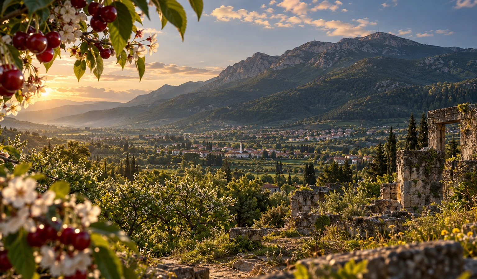
Journey from Neolithic Ulucak to Byzantine Kemalpaşa, traditional Nazarköy and Tarkasnawa's extraordinary Late Bronze Age monument at Karabel.
Plan Your Archaeology Day