Private Pehlivanköy Heritage Route
Ask us to design a private journey focused on Ottoman bridges, historic roads, railway heritage and the lesser-known landscapes of Turkish Thrace.
Request a Custom Tour





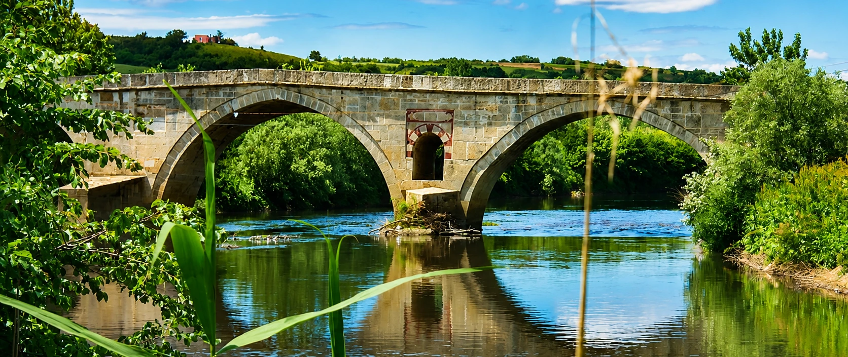
At the southern edge of Pehlivanköy, on the road toward Akarca and Uzunköprü, a long stone bridge carries the historic route across the Ergene River. Its seven openings rise toward a dominant central arch before becoming progressively smaller toward the ends.
The bridge has no complete foundation inscription, so neither its exact construction date nor its patron is securely known. Its form, materials and role on an important Ottoman route have led official inventories to date it to the 16th century.
Akarca Bridge was more than a river crossing. It helped maintain movement between settlements in Ottoman Thrace and supported the wider road network connecting Istanbul and the interior with Edirne and the Balkan lands beyond.
The monument remains part of the modern landscape. Its roadway has been asphalted and it has continued to serve local traffic, while the stone elevations, pointed arches and damaged Ottoman inscription preserve the strongest traces of its historic character.
The bridge is also remembered through a sombre local story about a master named Pavlu and a sacrifice said to have secured the central arch. This is folklore rather than documented construction history, but it remains an important part of Pehlivanköy's cultural memory.
The bridge is generally dated to the Ottoman period in the 1500s, although its precise year is unknown.
A high central opening is framed by six smaller arches that diminish toward the riverbanks.
The bridge carried a strategic route across one of the principal rivers of Turkish Thrace.
Unlike a museum exhibit, Akarca Bridge remains embedded in an active rural road and river landscape.
Essential information for understanding and safely viewing this historic Ergene River crossing.
Across the Ergene River south of Pehlivanköy, on the road toward Akarca and Uzunköprü.
Open on Google MapsExact date unknown; generally attributed to the 16th-century Ottoman period.
A seven-opening stone arch bridge with a prominent central span.
Commonly recorded as approximately 109 metres long and 7.25 metres wide.
Historic stone masonry, with later repairs and an asphalt-covered roadway.
No museum ticket; view the monument from safe, publicly accessible areas.
The bridge preserves a physical link in the transport network that joined Ottoman Thrace across the difficult floodplain of the Ergene.
Rivers were both resources and obstacles in the lowlands of Thrace. The Ergene watered a productive agricultural landscape, but seasonal changes and flooding could interrupt the movement of people, animals, goods and military forces. A permanent masonry crossing made travel more reliable than a ford or temporary wooden structure.
Akarca Bridge stood on a route linking Pehlivanköy with Uzunköprü and Edirne. In the wider Ottoman road system, crossings such as this helped bind Istanbul to the empire's European territories and supported commerce, administration, postal movement and campaigning armies.
Architecturally, the bridge demonstrates how Ottoman builders responded to a broad riverbed. The high central arch accommodated the principal channel, while progressively smaller side openings distributed the crossing across the floodplain.
Its importance also comes from continued use. Akarca Bridge did not become an isolated ruin after its historic role declined; it remained a working piece of local infrastructure and consequently accumulated repairs, road surfacing and other later interventions.
Today it is one of Pehlivanköy's principal cultural monuments, together with the district's historic railway heritage. The bridge expresses two different eras of regional mobility: the Ottoman stone road and the later railway landscape of Turkish Thrace.
The surviving inscription does not provide a complete answer to when or by whom Akarca Bridge was built. Its upper section is broken, and the part that would have contained decisive information—including a date—has not survived.
For this reason, the bridge is dated through architectural evidence, building material and historical purpose. Official cultural records classify it as an Ottoman bridge of the 16th century. The attribution is persuasive, but visitors should distinguish it from a precisely dated foundation confirmed by an intact inscription.
The construction belongs to an era when the Ottoman state invested in roads, bridges, caravanserais and charitable complexes across Rumelia. These structures eased the passage of travellers and goods while making imperial routes more dependable.
Akarca Bridge continued to be repaired as the route and the river tested its masonry. Its present appearance reflects the original Ottoman design together with later rebuilding, renewed parapets and the asphalt surface required by modern road use.
The monument's long working life is therefore central to its story. Rather than preserving a single untouched moment, it records centuries of adaptation around the same essential task: crossing the Ergene.
No securely preserved inscription identifies the patron or original master builder.
Official inventories date the bridge through its architecture, materials and place in the Ottoman road system.
River conditions, traffic and age made periodic intervention necessary throughout the bridge's history.
Its original function has continued even as the roadway and parapets have been altered or renewed.
The Ergene River flows through the broad agricultural plains of Turkish Thrace before joining the Meriç system. Although the landscape appears gentle, a river crossing here had to cope with changing water levels, sediment and a wide flood zone.
The bridge's sequence of seven openings allowed water to pass at more than one point rather than forcing the entire flow through a single span. The dominant middle arch marks the principal channel, while the smaller side arches helped manage water spreading across the approaches.
Its location on the Pehlivanköy–Uzunköprü–Edirne direction made the crossing part of a much larger geography. Edirne was an Ottoman capital and remained a major administrative and strategic centre; Uzunköprü itself grew around another monumental river crossing.
Seen in this context, Akarca Bridge was not an isolated work of architecture. It belonged to a connected landscape of roads, settlements, bridges and service buildings that made long-distance movement through Rumelia possible.
The tallest arch rises over the main flow and creates the visual centre of the bridge.
Smaller arches helped carry water through the wider river corridor during changing conditions.
The crossing supported regional travel toward Uzunköprü and one of the Ottoman Empire's most important cities.
The historic structure still connects communities on opposite sides of the Ergene landscape.
Akarca Bridge is a long masonry structure arranged on a roughly north–south axis. It is commonly recorded as approximately 109 metres long and 7.25 metres wide, dimensions that reflect both the breadth of the crossing and its continued road function.
The bridge has seven arched openings. The central span is the tallest and most commanding, while the arches become smaller toward the ends. This creates a gently rising profile and concentrates clearance above the principal river channel.
The elevations are deliberately restrained. Their architectural power comes from the rhythm of the pointed arches, the weight of the stone piers and the changing scale of the openings rather than elaborate surface ornament.
An additional arched opening appears within a central pier, helping relieve water pressure and reduce the mass exposed to the current. Near the main arch is a square marble inscription panel written in Ottoman script, but its upper portion is broken and its date is missing.
The road deck is now covered with asphalt, and the parapets and other areas show the results of later repair. These interventions should be read as part of a monument that has remained in use rather than as evidence of a completely untouched 16th-century surface.
One high central opening and three diminishing spans on either side form the bridge's characteristic rhythm.
The pointed arches direct loads into the heavy stone piers and create a distinctly Ottoman silhouette.
A smaller arched passage within a central support provides additional relief when the river rises.
The surviving Ottoman-script marble panel has lost the section that may once have recorded the bridge's date.
The broad elevations and substantial piers were designed for durability in a demanding river environment.
Asphalt and repaired parapets reveal the structure's adaptation to continued local traffic.
The bridge is best understood from a safe position beside the road and away from traffic. Look first at its complete profile, then focus on the engineering details, inscription and relationship with the Ergene River.
The largest opening creates the bridge's visual summit and spans the principal channel.
Follow how the six flanking openings decrease in size toward the approaches.
The massive supports reveal the structural logic needed to carry the road across a wide riverbed.
Look for the smaller arch formed within one of the central supports.
The broken marble panel survives near the principal opening, although its date is no longer preserved.
The low protective walls mark the road deck and include sections renewed during later repairs.
Reeds, water levels and the broad plain explain why a durable crossing was so valuable.
The bridge's orientation reveals the old road relationship between Pehlivanköy and Akarca.
Compare the stone elevations with the asphalt deck and other evidence of continued use.
When vegetation and water conditions permit, a side view gives the clearest reading of the complete structure.
Local tradition remembers a master builder named Pavlu or Pavlu Usta. According to the story, the builders repeatedly failed to secure the great central arch because the strong water of the Ergene undermined their work.
The legend says that the master concluded only a human sacrifice placed within the masonry could make the structure stand. The victim would be chosen from among the women who brought food to the workers, and the decision fell upon a young mother carrying her baby.
In the most haunting version, the woman was immured in the bridge while still nursing her child. People later said that a woman's crying could be heard near the pier on Friday nights and that milk flowed between two stones.
This narrative belongs to a widespread family of Balkan bridge-building legends in which a life is imagined as the price of permanent construction. It should not be presented as a documented historical event, but as folklore expressing communal memories of dangerous rivers, difficult engineering and the human cost associated with monumental works.
The traditional master builder gives the story a personal name, although his historic identity is unproven.
Repeated failure at the river's strongest point forms the dramatic beginning of the legend.
Her tragic fate transforms an engineering story into a tale of grief, injustice and remembrance.
The story is part of local oral culture and should remain clearly separate from the bridge's documented history.
Akarca Bridge is an outdoor roadside monument rather than a staffed attraction. There is no ticket office, exhibition route or formal visitor centre at the bridge.
Because the crossing has served local road traffic, visitors must remain alert to vehicles and avoid stopping on the carriageway. Riverbanks may be muddy, overgrown, steep or flooded, and safe access below the bridge cannot be assumed.
The bridge can be seen throughout the year, but dry weather makes roadside and riverbank conditions easier. Morning or late-afternoon light gives the arches more depth and reveals the texture of the masonry.
Cooler conditions and softer light suit a short architectural visit.
Low angled light can define the arches, piers and long bridge profile.
The plain is green, but rain, high water and vigorous reeds can limit riverbank views.
Drier ground and mild temperatures often make regional road trips more comfortable.
Avoid descending toward the river; mud, unstable banks and raised water can create serious hazards.
Fog can be atmospheric, but frost, wind and poor road visibility require additional caution.
Akarca Bridge is a focused heritage stop rather than a large archaeological complex. Most visitors can appreciate it within half an hour, while a longer route can include Pehlivanköy and nearby Ottoman monuments.
Enough for a safe roadside overview and several photographs of the main arch.
Best for examining the full profile, inscription area and river setting without rushing.
Useful for photographers when safe viewpoints, water levels and vegetation allow broader compositions.
Combine Akarca Bridge with Pehlivanköy station, Babaeski Bridge and the monuments of Babaeski.
The most informative photograph shows the relationship between the central arch, smaller openings and the flat Ergene landscape. Always choose a safe position away from moving traffic and unstable riverbanks.
A side view reveals the seven-opening sequence and the changing heights of the arches.
Frame the largest opening with its neighbouring piers to emphasize the engineering hierarchy.
Side light brings out masonry joints, weathering and later repairs.
Use a zoom lens from safe ground rather than climbing or leaning over the parapet.
Include the Ergene landscape to explain the bridge's function and rural setting.
Confirm current aviation rules, local restrictions and heritage-site requirements before any flight.
The bridge crosses the Ergene approximately 1.2 kilometres south of Pehlivanköy and about 1 kilometre west of Akarca village. It lies on the local road continuing toward Uzunköprü and Edirne.
Follow the road south toward Akarca and Uzunköprü; the bridge is only a few minutes from the town centre by car.
Approach eastward through the rural road network toward Akarca and Pehlivanköy, using current navigation.
Continue west and southwest through the district road network for a route linking two historic Ottoman bridges.
Travel south toward Babaeski and continue to Pehlivanköy; allow time for regional roads and current conditions.
Drive east toward Uzunköprü and continue in the Pehlivanköy direction using live navigation.
Pehlivanköy has rail and regional transport connections, but onward access to the bridge may require a taxi or local arrangement.
The bridge fits naturally into a route through Pehlivanköy, Babaeski, Lüleburgaz, Uzunköprü and Edirne, where Ottoman roads, railway heritage and monumental architecture tell the wider story of Turkish Thrace.
See the historic station complex associated with the railway routes that transformed movement through Thrace in the late 19th century.
Compare Akarca's seven arches with another important Ottoman stone crossing in Kırklareli Province.
Visit Babaeski's distinguished 16th-century mosque and explore the town's Ottoman architectural heritage.
Continue to Lüleburgaz for one of Mimar Sinan's major mosque and caravan-route complexes in Thrace.
Explore the town named for the monumental Ottoman bridge built across the Ergene floodplain.
Discover imperial mosques, bridges, museums and the layered heritage of the Ottoman Empire's former capital.
Plan a wider journey through prehistoric sites, Ottoman monuments, historic towns, forests and the Black Sea coast.
If dates coincide, experience Pehlivanköy's long-established autumn fair and the district's living community traditions.
It crosses the Ergene River just south of Pehlivanköy in Kırklareli Province, on the road toward Akarca village, Uzunköprü and Edirne.
Its precise date is unknown because the relevant part of the inscription is missing. Official cultural inventories generally attribute it to the 16th-century Ottoman period.
No securely preserved historical record identifies the patron or architect. A master called Pavlu appears in local folklore, but this is a legendary rather than proven attribution.
Akarca Bridge has seven arched openings, with the largest in the middle and smaller arches toward both ends.
Published descriptions commonly record the bridge as approximately 109 metres long and 7.25 metres wide.
It crosses the Ergene River, one of the principal waterways of Turkish Thrace.
An Ottoman-script marble panel survives near the central opening, but its upper part is broken. Because the missing section appears to have included the date, the bridge cannot be dated precisely from the inscription.
The bridge has continued to function as a road crossing and its deck is asphalted. However, local authorities assessed deterioration and safety concerns in 2026, so visitors should verify current traffic and access conditions.
No. Akarca Bridge is an outdoor roadside monument rather than a ticketed museum.
The monument is normally visible from public areas, but road works, structural inspections, flooding or conservation measures may change access without notice.
Pedestrian conditions depend on current traffic management and the available space beside vehicles. Follow local signs, never obstruct the carriageway and do not attempt to cross if it cannot be done safely.
Do not assume that riverbank access is safe. Reeds, mud, steep ground, private land and changing water levels may make descent dangerous or inappropriate.
Local folklore says that a young mother was sacrificed within the masonry after the central arch repeatedly failed. The tale also remembers a master named Pavlu and a woman's cries near the bridge, but it is legend rather than documented history.
Allow approximately 20–40 minutes for a careful view and photographs from safe locations.
The bridge can be seen from the road, but safe stopping space and level pedestrian access may be limited. Unpaved riverbank viewpoints are generally unsuitable for wheelchairs.
Nearby possibilities include Pehlivanköy Railway Station, Babaeski Bridge, Cedid Ali Pasha Mosque, Lüleburgaz's Sokullu Mehmed Pasha Complex, Uzunköprü and Edirne.
Yes—especially for travellers interested in Ottoman engineering, historic roads and lesser-known monuments of Turkish Thrace. It works best as part of a regional heritage route rather than as a stand-alone full-day destination.
Never stand in the road, stop on the bridge or step into a vehicle's path for a photograph.
Obey barriers, warning signs and temporary closures related to safety or conservation.
Stay off parapets, piers, inscription panels and all historic masonry.
Avoid trampling reeds, disturbing wildlife or descending onto unstable and muddy ground.
Every stone and fragment belongs to the protected historic structure and its setting.
Take all litter away and never carve, paint or attach anything to the bridge.
Follow the historic roads of Thrace through Pehlivanköy, Babaeski, Lüleburgaz and Edirne, combining stone bridges, imperial architecture, railway heritage and rural landscapes.
Combine Akarca Bridge with the historic station at Pehlivanköy, Babaeski's monuments and other Ottoman crossings on a tailor-made journey through western Kırklareli.
Ask us to design a private journey focused on Ottoman bridges, historic roads, railway heritage and the lesser-known landscapes of Turkish Thrace.
Request a Custom Tour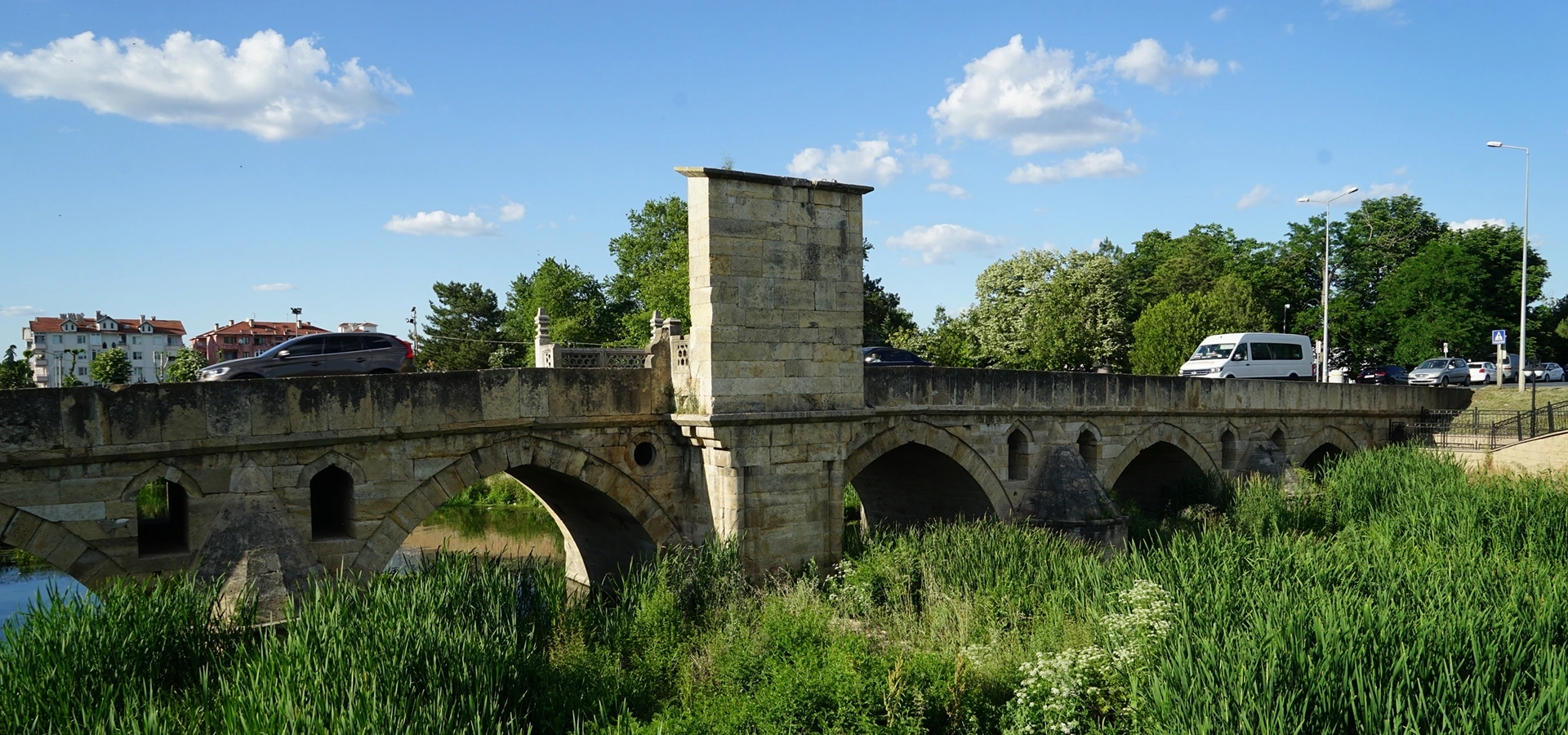
Continue to another important Ottoman crossing and compare its long stone profile, arches and road history with Akarca Bridge.
View Babaeski Bridge GuideDiscover more Ottoman architecture, historic towns and cultural landscapes across Kırklareli Province.
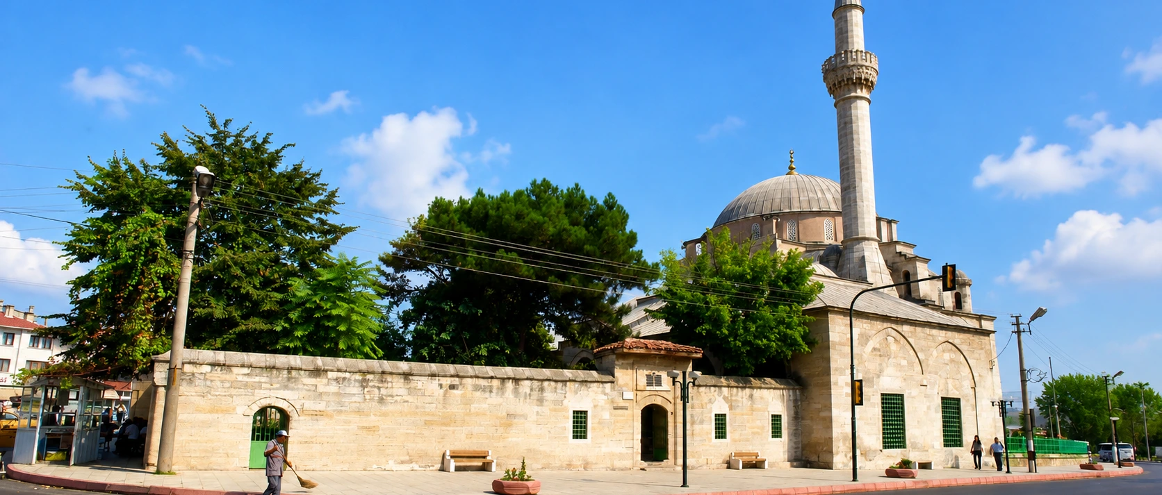
Explore a distinguished 16th-century Ottoman mosque and the architectural heritage of historic Babaeski.
Discover the Mosque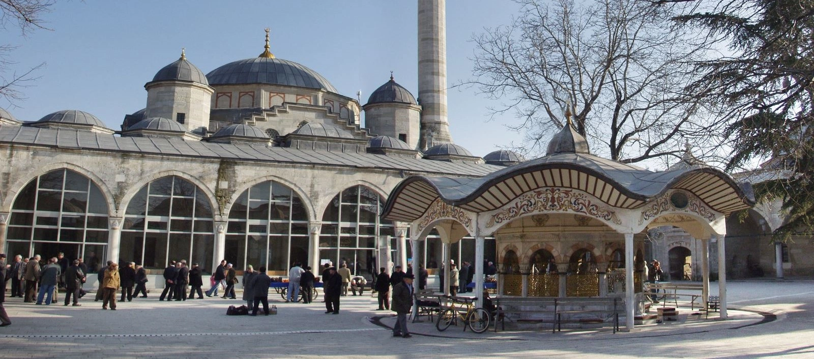
Visit Mimar Sinan's great Lüleburgaz complex, created to serve worship, trade and travel on the Ottoman road through Thrace.
Discover the Complex
Plan a wider journey through prehistoric settlements, Ottoman monuments, historic towns, forests, caves and the Black Sea coast.
View Kırklareli Guide