Private Körteke Castle Experience
Ask about a tailor-made archaeological excursion exploring Körteke Castle, ancient Carian heritage and the surrounding Bozdoğan countryside, subject to local access conditions.
Request a Custom Experience





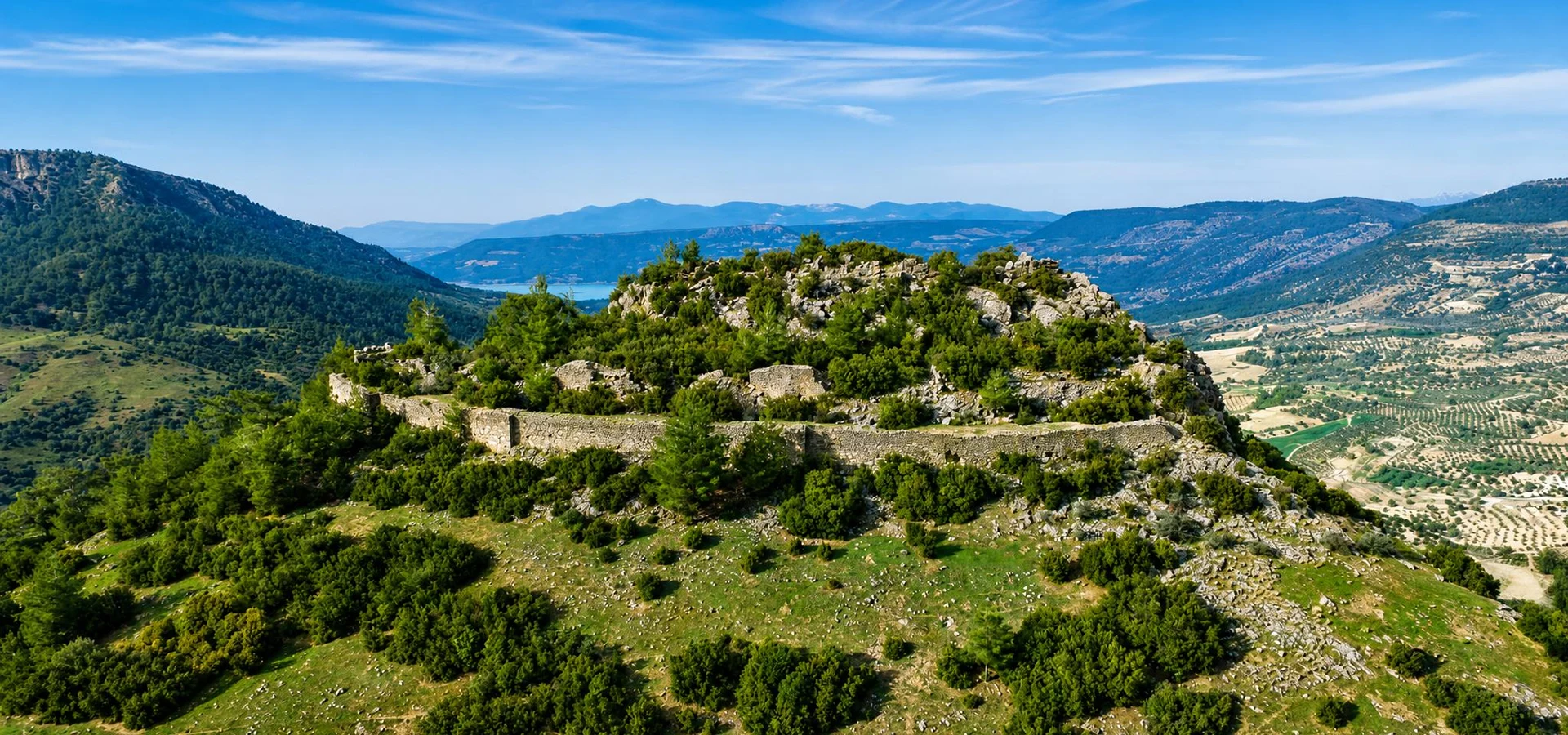
Hidden among the rugged hills of southwestern Türkiye, Körteke Castle (Körteke Kalesi) is one of the lesser-known archaeological landmarks of Aydın Province. Located near Körteke village in the Bozdoğan district, the fortress occupies a commanding rocky summit known as Kale Tepe, overlooking a landscape of mountains, wooded slopes and agricultural valleys.
Unlike the monumental coastal fortresses associated with later medieval or Ottoman history, Körteke Castle preserves evidence of a much earlier fortified settlement. Archaeological descriptions associate the site with the hilltop settlement traditions of ancient Caria (Karia), a culturally distinctive region of western Anatolia whose communities developed settlements, defensive walls and religious centers long before Roman rule.
The surviving fortifications include an acropolis, towers, defensive walls and a central cistern. The southern enclosure, distinguished by three towers, has been dated to approximately the 5th century BC. Differences in the surviving masonry suggest that the fortified site was also used or modified during later periods.
Some official archaeological descriptions tentatively identify the settlement with Xyatis, an ancient Carian place whose precise identification is not firmly established. This possibility adds historical interest to the ruins, although the name should not be treated as a proven identification.
Today, Körteke Castle appeals especially to travelers who enjoy exploring quiet archaeological landscapes away from major tourist routes. There are no vast reconstructed palaces or elaborate visitor exhibitions. Instead, its significance emerges from the relationship between natural rock, surviving masonry, defensive architecture and an extraordinary elevated position.
Discover a fortified hilltop settlement associated with the early history of inland Caria.
Examine surviving defenses attributed to the Classical period.
Explore a site tentatively connected with an ancient Carian settlement.
Enjoy views across the hills and valleys surrounding Bozdoğan.
Essential information for discovering this ancient Carian fortress in Aydın.
Kale Tepe, northeast of Körteke village, Bozdoğan district, Aydın, Türkiye.
Open on Google MapsInland Caria, one of the historically important cultural regions of southwestern Anatolia.
The southern acropolis fortification is attributed to the 5th century BC.
Acropolis, fortified walls, eastern and western towers, a cistern and a three-towered southern enclosure.
Approximately 40 km from Bozdoğan district center, according to the local municipality.
Free entry according to Bozdoğan Municipality; verify access conditions before traveling.
Allow approximately 1–2 hours for exploration, depending on access, terrain and photography.
Outdoor archaeological exploration on a rocky hilltop, best suited to visitors comfortable with uneven ground.
A rare opportunity to understand the defensive landscapes and settlement traditions of ancient inland Caria.
Körteke Castle is important because it preserves evidence of a fortified hilltop settlement within the historical territory of Caria. Although the region is internationally known for spectacular archaeological sites such as Aphrodisias, many smaller settlements remain outside the usual tourist itinerary.
The castle represents a different aspect of ancient life. Rather than a monumental urban center with theaters and colonnaded streets, it illustrates how communities could use naturally defensible terrain, stone fortifications and carefully positioned towers to protect important high ground.
The steep summit of Kale Tepe offered a significant natural advantage. Approaches could be observed from above, while rocky slopes reduced the number of routes by which attackers could reach the enclosure. Defensive walls strengthened the more vulnerable sides of the settlement.
The surviving cistern is particularly significant. A fortified settlement required reliable water storage, especially when access to springs or streams might be interrupted. The presence of a cistern suggests attention to the practical needs of people occupying the elevated site.
Körteke also contributes to broader questions about settlement patterns in ancient Caria. Its possible association with Xyatis remains uncertain, but the ruins demonstrate the existence of substantial defensive architecture in a part of Aydın that receives comparatively little archaeological tourism.
For visitors, the castle provides something increasingly uncommon: a historic landscape where natural topography and surviving ruins can still be experienced together, without the atmosphere of a large commercial attraction.
The history of Körteke Castle belongs to the complex archaeological heritage of southwestern Anatolia. During antiquity, the mountainous interior of Caria contained numerous settlements whose inhabitants adapted their architecture and defensive systems to difficult terrain.
Some of these communities occupied naturally protected hilltops. Stone fortifications could reinforce steep slopes, while towers and gates controlled access to areas used for protection, administration or settlement.
Official cultural heritage descriptions classify Körteke as a Leleg-type hilltop settlement of inland Caria. The term reflects a traditional archaeological classification associated with fortified settlements in the wider Carian region. It should not be understood as definitive proof of the ethnicity or identity of every inhabitant.
The site may have developed within a wider network of settlements connected by valleys, agricultural lands and mountain routes. Its prominent position would have made the hill useful for observing surrounding terrain.
The clearest chronological reference comes from the surviving inner fortifications on the southern side of the acropolis. The Aydın Provincial Directorate of Culture and Tourism dates this defensive enclosure, including its three towers, to the 5th century BC.
This places the dated fortification within the Classical period, a time when western Anatolia experienced changing political relationships involving local communities, Persian authority and the Greek-speaking cities of the Aegean world.
However, the date assigned to the fortification should not automatically be applied to every surviving wall, tower or structure at Körteke.
Variations in the masonry indicate that Körteke Castle may have remained in use or undergone modifications in different historical periods. The published descriptions do not establish a complete sequence of construction campaigns, and individual sections should not be assigned precise later dates without supporting archaeological evidence.
The wider Bozdoğan region passed through Roman, Byzantine and medieval Turkish historical phases. These regional developments provide background for understanding the area, but they do not by themselves establish which rulers rebuilt or occupied each part of the castle.
Today, the site survives as an open-air archaeological landscape. Its visible features include portions of defensive walls, tower remains and the central water-storage structure.
Vegetation, erosion and natural weathering influence the appearance of the ruins. The castle is therefore best approached as a historic site where observation and interpretation matter more than reconstructed architecture.
The hill belongs to a region with a long tradition of fortified inland settlements.
The southern inner wall and its three towers are attributed to the Classical period.
The ancient name remains a tentative archaeological identification.
Differences in wall construction suggest use or modification across different periods.
The remains are recognized in official provincial and municipal heritage listings.
The castle remains a quiet outdoor site in the mountainous countryside of Bozdoğan.
One of the most intriguing questions about Körteke Castle concerns the identity of the ancient settlement associated with its fortifications.
Official descriptions suggest that the site may correspond to Xyatis, an ancient place associated with the Carian landscape. This identification is significant because matching surviving ruins with historical place names can help archaeologists reconstruct settlement geography and regional connections.
However, identifying an ancient settlement is rarely as simple as finding a defensible hill. Archaeologists must consider inscriptions, ancient geographical references, material remains, construction chronology and relationships with neighboring sites.
At Körteke, the proposed identification has not been presented by the official sources as conclusively established. Visitors should therefore distinguish between the physical remains, which can be observed, and the ancient name, which remains an interpretation.
If the connection with Xyatis were securely established, Körteke would provide a geographical anchor for studying a settlement in inland Caria. Its walls, towers and water-storage system could then be examined in relation to a more clearly identified ancient community.
Until that identification is demonstrated, Körteke Castle is valuable in its own right as an archaeological example of hilltop fortification in western Anatolia.
A fortified ancient hilltop site survives on Kale Tepe near Körteke.
The site has been tentatively identified with the ancient settlement of Xyatis.
The full settlement history, ancient name and detailed chronology of later building phases.
The surviving architecture of Körteke Castle reflects the relationship between ancient defensive engineering and the natural form of Kale Tepe. Rather than occupying a level urban site, the fortress follows the contours of a rocky elevation.
The principal archaeological features described by the cultural authorities are the acropolis, eastern and western towers, a central cistern and the southern inner enclosure strengthened by three towers.
The word acropolis comes from Greek and generally refers to the elevated or upper fortified area of an ancient settlement. At Körteke, this area occupies the rocky summit and forms the central archaeological focus.
Its location illustrates the advantage of choosing high ground. Steep surrounding terrain could reduce the need for defensive construction along some approaches, while more exposed directions required substantial walls.
Surviving stone walls mark the fortified enclosure. The southern sector is especially important because the inner wall, with its three towers, has been dated to the 5th century BC.
The fortress walls should be examined as a combination of ancient construction and later alteration. Differences in masonry may help specialists distinguish between building phases, although visitors should avoid assigning specific dates to individual stones without archaeological documentation.
The site includes tower remains to the east and west of the acropolis. The southern fortification is also described as having three towers.
In ancient fortification systems, towers improved observation and helped defenders oversee approaches to a wall. At Körteke, their strategic value is easiest to understand by considering the surrounding slopes and the routes by which people could approach the summit.
The cistern is one of the most revealing features of the site. Elevated fortresses required water-storage arrangements, particularly where water sources lay below the protected area.
Although the precise ancient water-management system has not been fully documented in the publicly available descriptions, the surviving cistern demonstrates that water storage formed part of the fortified complex.
The naturally elevated core of the fortified settlement.
A major defensive enclosure dated to approximately the 5th century BC.
Structural elements strengthening the main southern defensive line.
A surviving component of the acropolis fortification system.
Another principal tower remain identified in official archaeological descriptions.
Evidence that the ancient occupants provided for water storage inside the fortified area.
A visit to Körteke Castle is most rewarding when approached as a small archaeological exploration rather than a conventional castle tour. The attraction lies in examining surviving structures while understanding their relationship with the surrounding landscape.
Experience the elevated rocky location chosen for the ancient fortified settlement.
Explore the identifiable upper settlement area and surviving defensive masonry.
Look for the remains of the inner defensive enclosure associated with three towers.
Observe the principal tower locations and how they relate to the summit.
Study the surviving water-storage feature as evidence of practical settlement planning.
Notice variations in masonry that may reflect different construction or repair phases.
Observe the steep slopes and rocky terrain that contributed to the fortress's strategic location.
Enjoy elevated views across wooded hills, agricultural country and distant mountains.
Körteke Castle's setting is essential to understanding its history. The fortifications occupy elevated ground northeast of Körteke village, where the surrounding relief creates a natural defensive position.
In ancient warfare, a well-positioned hilltop could offer several practical advantages. Elevated observation helped communities identify approaching movement, while steep ground slowed attackers and limited the directions from which they could advance.
Hilltop fortifications also illustrate a compromise between protection and everyday needs. Although high ground could be easier to defend, food, water and communication with nearby settlements still had to be maintained.
At Körteke, the presence of a cistern is a useful reminder of this balance. Defensive architecture alone could not sustain a population unless basic requirements were addressed.
The elevated location offers views across sections of the surrounding countryside.
Natural terrain helped restrict access to parts of the fortified summit.
Defensive walls and towers could strengthen the routes most vulnerable to entry.
A cistern reduced dependence on immediate access to water outside the enclosure.
Ancient Caria occupied much of southwestern Anatolia, including areas of today's Aydın and Muğla provinces. Its geography was diverse, combining Aegean coastal settlements, fertile valleys, rugged hills and mountainous inland districts.
Carian communities participated in a complex cultural world shaped by local traditions and contacts with neighboring Anatolian, Greek and Persian societies. Their architectural heritage includes sanctuaries, settlements, tombs and fortifications.
Körteke Castle offers an especially useful perspective on the smaller inland settlements that rarely receive the same attention as major archaeological cities.
The official classification of Körteke as a Leleg-type hilltop settlement places it within an archaeological discussion about fortified communities in Caria.
Ancient writers referred to peoples known as Leleges, but the relationship between those literary traditions and individual archaeological sites remains complicated. Architectural comparisons can be useful without proving a precise ethnic identity.
Travelers interested in Carian history can compare Körteke with archaeological landscapes elsewhere in Aydın. Monumental sites such as Aphrodisias present a much more extensively documented urban environment, while smaller hilltop ruins reveal other patterns of settlement and defense.
Visiting different kinds of archaeological sites provides a broader understanding of how communities adapted to local geography over many centuries.
Körteke Castle is situated in a rural hilltop environment. Visitors should prepare for a different experience from a managed archaeological park with paved pathways, staffed entrances and extensive facilities.
Choose walking or hiking shoes with good grip for uneven stone and natural ground.
Bring enough water for the visit, particularly during warm weather.
Plan exploration during daylight and allow time to return safely before sunset.
A hat, sunscreen and suitable clothing are advisable during spring and summer.
Check current access to the village and the final approach before setting out.
Save an offline map because rural roads and mobile coverage can vary.
Do not approach exposed drops or climb unstable historic structures.
The combination of ruins and countryside offers excellent landscape photography opportunities.
Begin by traveling through the Bozdoğan countryside toward Körteke village, following the local road directions and confirming where vehicle access ends. Take time to appreciate the position of Kale Tepe before approaching the archaeological remains.
Where a safe and permitted approach is available, begin your exploration with the outer appearance of the fortifications. Observing the walls from a little distance makes it easier to understand their relationship with the rocky terrain.
Continue toward accessible sections of the acropolis, paying attention to surviving tower remains and the defensive line on the southern side of the summit. Look for differences in the stonework, but avoid crossing unstable sections.
If the route is safe, locate and observe the central cistern from a secure position. Consider why water storage would have been essential to the occupation of a hilltop fortress.
Finish with time for panoramic photography and observation of the surrounding landscape. The views help explain why this particular hill was chosen for fortification.
Körteke Castle is listed by Bozdoğan Municipality as a historic site that can be visited without an entrance fee. The municipal description places the castle approximately 40 kilometers from Bozdoğan district center and recommends following the road toward Çamlıdere village.
The national educational site listing describes Körteke Castle as accessible throughout the week. However, this should not be interpreted as a guarantee of staffed services, unrestricted access to every ruin or safe conditions after dark.
Because Körteke is a rural archaeological location rather than a conventional ticketed museum, visitors should verify road access and any temporary local restrictions before traveling.
The best time to visit Körteke Castle depends largely on weather and ground conditions. Since the experience takes place outdoors on elevated natural terrain, moderate temperatures and dry surfaces make exploration more comfortable.
Generally pleasant for exploring the landscape, with greener hillsides and comfortable temperatures.
Longer daylight is useful, but carry water and avoid the hottest hours.
Often a rewarding season for walking, landscape photography and milder conditions.
Rain, wind and slippery rock may make exposed areas difficult or unsafe.
A good choice for cooler conditions and a relaxed visit before the midday heat.
Attractive light for photographs, provided you allow enough time to leave before darkness.
Körteke Castle is a relatively compact archaeological destination, but reaching the site and navigating the terrain may require additional time. The following durations are planning suggestions rather than official tour lengths.
Suitable for a brief exterior overview where vehicle access and safe viewing points permit.
Allow time for selected visible ruins, landscape views and basic photography.
A comfortable target for examining multiple features without rushing, when safely accessible.
Useful for visitors particularly interested in archaeology, fortifications and landscape photography.
Allow for the journey from Bozdoğan, the castle and a scenic stop in the surrounding countryside.
Combine the fortress with another regional destination, subject to access and travel arrangements.
Körteke Castle offers opportunities for both archaeological detail photography and wider landscape compositions. The weathered ruins blend into the surrounding hillside, making natural light and viewpoint selection especially important.
Frame the remaining defensive walls against the surrounding mountain landscape.
Photograph stonework, joints and visible changes in construction technique.
Show how built fortifications interact with natural formations.
Use carefully selected safe angles to highlight the surviving defensive structures.
Side lighting can reveal textures in weathered stone and vegetation.
Capture the relationship between the castle and the rural Bozdoğan countryside.
Accessibility at Körteke Castle should be assessed according to the actual route and the visitor's mobility needs. The castle occupies an irregular rocky hilltop rather than a landscaped urban archaeological park.
Although an educational directory includes general accessibility and guidance information, the publicly available descriptions do not provide sufficient detail to confirm a continuous step-free route to all archaeological features.
Visitors may encounter loose stone, natural slopes and irregular surfaces.
Do not assume wheelchair access to the acropolis; request specific local guidance before traveling.
The final approach may be more demanding than the short distance between visible ruins suggests.
Close adult supervision is essential near rocks, steep slopes and historic wall remains.
Consider an exterior viewing visit if climbing or uneven ground is difficult.
Natural archaeological terrain may make stroller use impractical.
Körteke Castle is situated northeast of Körteke village in the Bozdoğan district of Aydın Province. Bozdoğan Municipality describes the site as being approximately 40 kilometers from Bozdoğan district center and advises visitors to follow the route toward Çamlıdere village.
Because the castle lies in a rural setting, it is advisable to use current navigation and confirm the condition of the final approach rather than relying only on a general district map.
Follow the local road network toward Çamlıdere and Körteke, checking current directions to Kale Tepe.
Travel toward Bozdoğan before continuing through the district's rural roads toward Körteke.
Reach the Bozdoğan region by road and continue toward the castle using updated local navigation.
Generally the most practical option for a flexible visit to a remote archaeological destination.
Village transport may be limited; confirm services and return arrangements in advance.
Check where safe vehicle access ends and whether walking is necessary to reach the ruins.
Körteke Castle can form part of a wider exploration of inland Aydın, where archaeological heritage, rivers, mountains and rural settlements create a landscape very different from the province's coastal destinations.
A natural pool associated with the Deliçay watercourse, surrounded by rugged scenery. Access involves natural terrain and should be checked locally.
A dramatic canyon associated with the Akçay and Kemer Dam landscape, known for its steep rock formations and scenic waterways.
Discover the reservoir landscape and surrounding rural scenery of the Bozdoğan region.
Experience the district's local atmosphere, traditional streets and regional history.
Explore the mountainous landscape that defines much of inland southern Aydın.
Discover traces of older routes and regional infrastructure around the Bozdoğan countryside.
Travelers with more time can extend their itinerary beyond the immediate Körteke area to explore other historical destinations in Aydın. These are regional extensions rather than attractions located directly beside the castle.
Discover a striking historic fortified residence in the Nazilli region, representing a very different chapter of Aydın's architectural heritage.
Explore a traditional town associated with regional craftsmanship and the archaeological heritage of ancient Caria.
See exceptional ancient sculptures and artifacts connected with one of Caria's most celebrated archaeological cities.
Continue exploring the ancient settlements and historical geography of the Büyük Menderes region.
Körteke Castle is located on Kale Tepe, northeast of Körteke village in the Bozdoğan district of Aydın Province, southwestern Türkiye.
It is an ancient fortified hilltop archaeological site containing an acropolis, defensive walls, towers and a central cistern.
The southern inner fortification and its three towers have been dated to the 5th century BC, approximately 2,500 years ago. Other visible construction may belong to different periods.
The identity of its original builders is not securely established. The site is associated with the fortified settlement traditions of ancient inland Caria.
The site lies within ancient Caria and is described as a Leleg-type hilltop settlement, but that classification does not conclusively identify the original builders.
Possibly. Official cultural heritage descriptions propose that the settlement may be Xyatis, but the identification remains tentative.
An acropolis is an elevated area of an ancient settlement, often fortified and sometimes containing important buildings or defensive structures.
Visitors can find surviving defensive walls, tower remains, the rocky acropolis and a central cistern, although visibility and access depend on current site conditions.
Official descriptions identify eastern and western tower remains and a southern inner fortification described as having three towers. These refer to features of the surviving defensive complex.
A cistern stores water. At an elevated fortified site, water storage would have helped provide for occupants when access to outside supplies was difficult.
Yes. Bozdoğan Municipality lists the castle as having no entrance fee. Check current local access conditions before traveling.
The national educational listing describes the site as accessible throughout the week. Because this is an outdoor archaeological location, visitors should explore in daylight and verify any current restrictions.
Bozdoğan Municipality gives an approximate distance of 40 kilometers from the district center.
The municipality recommends following the road toward Çamlıdere village from Bozdoğan. Use up-to-date navigation and verify the final approach.
The available official descriptions do not establish that every vehicle can reach the summit. Check local road conditions and be prepared for a possible walk.
It may be challenging for visitors uncomfortable with uneven natural ground, slopes or rocky archaeological terrain. Difficulty depends on the route used.
Children interested in history and nature may enjoy the site, but they need close supervision around unstable masonry, steep slopes and exposed rocks.
A continuous accessible route to the acropolis has not been confirmed in the available public descriptions. Contact local authorities for current access details.
Approximately 1–2 hours is a reasonable planning allowance for the site itself, although the duration depends on walking conditions, photography and the extent of safe access.
Spring and autumn are generally comfortable for outdoor exploration. Avoid very hot conditions, heavy rain and strong winds.
Do not rely on facilities at the ruins. Bring drinking water and obtain supplies in nearby settlements before visiting.
Kral Havuzu is a natural pool in the Körteke area associated with the Deliçay watercourse and the broader Arapapıştı Canyon landscape.
Yes, the two destinations can be considered for a regional excursion, although road conditions, travel times and canyon access should be confirmed.
The available official visitor descriptions do not establish an active excavation program or a public excavation schedule at the site.
Yes, particularly for travelers interested in ancient Caria, historic fortifications, quiet archaeological landscapes and the natural scenery of inland Aydın.
Small archaeological sites are especially vulnerable to erosion, careless climbing and disturbance of surviving masonry. Responsible exploration helps preserve Körteke Castle for future generations.
Ancient masonry may be unstable and can be damaged by climbing.
Never move archaeological stones or rearrange ruins for photographs.
Do not collect pottery fragments, stone objects or any archaeological materials.
Avoid unnecessary damage to plants and natural ground around the site.
Take bottles, packaging and other rubbish away with you.
Do not block agricultural tracks, enter private land without permission or disturb residents.
Avoid steep edges, concealed holes and unstable or restricted areas.
Respect any barriers, conservation instructions and archaeological restrictions.
Explore the archaeological landscapes of inland Aydın through thoughtfully planned private travel experiences combining ancient history, local heritage and natural scenery, without compulsory shopping stops.
Discover quiet historical places and dramatic natural landscapes with an itinerary tailored to your interests and practical access conditions.
Ask about a tailor-made archaeological excursion exploring Körteke Castle, ancient Carian heritage and the surrounding Bozdoğan countryside, subject to local access conditions.
Request a Custom Experience
Discover a wider selection of archaeological sites, traditional towns and historic landscapes across Aydın through a customized private itinerary.
Plan Your Aydın JourneyFrom ancient cities and sculpture collections to traditional architecture, discover the many layers of western Anatolia.
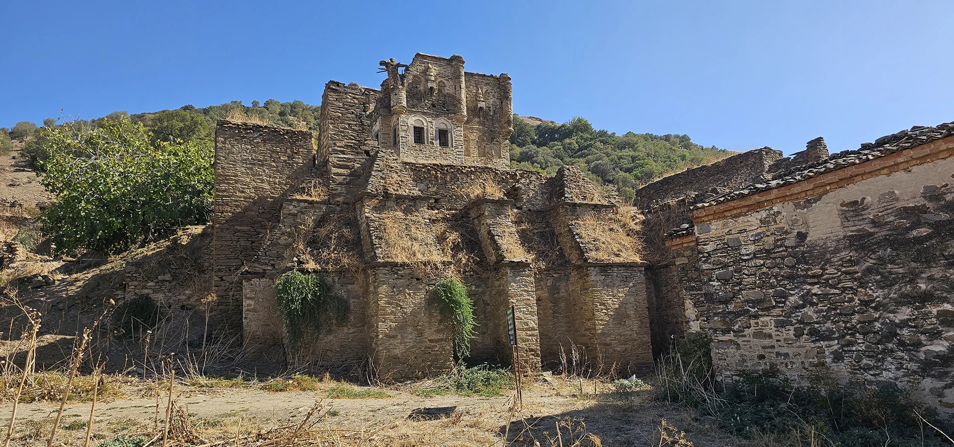
Explore a remarkable fortified historic complex in the Nazilli countryside.
Explore Arpaz Castle
Discover traditional craftsmanship, local culture and the heritage of ancient Caria.
Explore Karacasu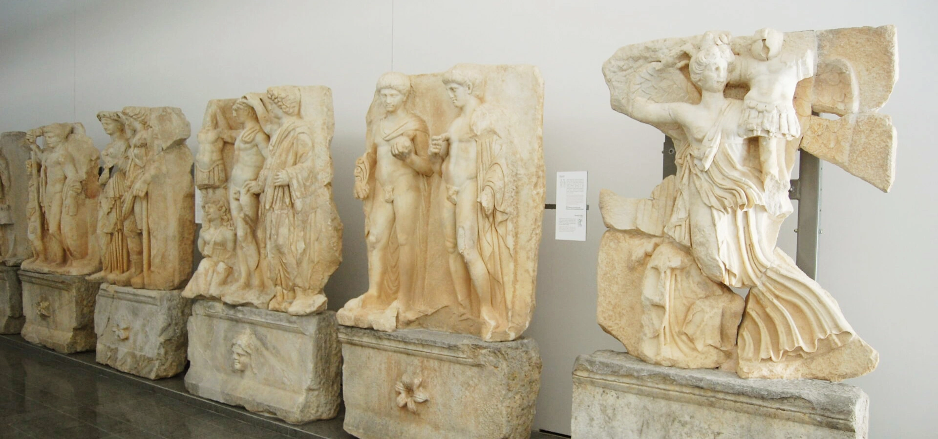
Discover extraordinary sculpture and archaeological finds from one of the great artistic centers of the ancient world.
Explore Aphrodisias Museum