Ancient Caria, Roman Heritage & Byzantine History

Antiocheia ad Maeandrum – Ancient City of the Meander Valley

Discover a forgotten city above the Büyük Menderes River,
where ancient trade routes, Roman ruins and Byzantine history meet.

Explore Ancient Antiocheia

Antiocheia ad Maeandrum – A Forgotten City of Ancient Caria

Hidden among the hills and agricultural landscapes of western Türkiye, Antiocheia ad Maeandrum is one of the lesser-known ancient cities of Aydın Province. Located near Başaran and Azizabat in the district of Kuyucak, the settlement occupied a strategic position above the meeting of the Büyük Menderes River, known in antiquity as the Maiandros, and the Dandalaz River, the ancient Morsynos.

Unlike the monumental ruins of Ephesus or Aphrodisias, Antiocheia remains largely unexplored by systematic archaeology. Its scattered stone blocks, traces of public buildings and substantial defensive walls preserve the story of a city that participated in the political, economic and military history of Anatolia for many centuries.

Antiocheia developed in a region historically associated with Caria and became closely connected with the Hellenistic kingdoms, Roman administration and the changing frontiers of the Byzantine world. Its location allowed the inhabitants to oversee important roads, agricultural lands and a historic crossing of the Meander River.

The city's most dramatic chapter came in AD 1211, when forces of the Empire of Nicaea and the Seljuk Sultanate of Rûm fought a major battle in the surrounding region. Today, its quiet ruins offer an opportunity to explore a remarkable but often overlooked part of Aydın's archaeological heritage.

Ancient Caria

Discover a historic settlement at the eastern side of the Carian landscape.

Roman Heritage

Explore traces of a stadium, ancient building remains and historic roads.

Byzantine Fortress

Examine surviving fortifications built and modified over several centuries.

Battle of 1211

Learn about a decisive confrontation between Nicaean and Seljuk forces.

Know Before You Go

Antiocheia ad Maeandrum – Quick Facts

Essential information about the ancient city and its historical setting.

📍

Location

Near Başaran and Azizabat, Kuyucak district, Aydın Province, Türkiye.

Open on Google Maps
🏛️

Historical Region

Ancient Caria, overlooking the Büyük Menderes Valley.

📜

Main Periods

Hellenistic, Roman and Byzantine, with earlier settlement traditions.

🏟️

Principal Remains

Defensive walls, stadium traces, architectural fragments and other ruins.

⚔️

Famous Event

The Battle of Antioch on the Meander in AD 1211.

🔎

Archaeological Status

Little excavated, with much of the ancient settlement still unexposed.

⏱️

Suggested Visit

Approximately 1–2 hours on site, depending on access and terrain.

🎟️

Visitor Access

Formal opening hours and ticket arrangements are not reliably published; confirm locally.


An Ancient Crossroads of Western Anatolia

Why Is Antiocheia ad Maeandrum Important?

Its significance lies in geography, regional trade, Roman urban life and Byzantine military history.

The importance of Antiocheia cannot be measured only by the monuments visible today. The city stood near a strategically valuable junction where routes along the Meander Valley connected with roads leading southward through Caria.

One important ancient route followed the valley eastward from the Aegean region. Another connection ran toward Aphrodisias and the upland territory around Tabae, near modern Tavas. The settlement's position made it possible to control traffic, communicate with neighboring cities and oversee a historic river crossing.

Fertile alluvial soils supported agriculture in the surrounding valley. Agricultural production, trade and the movement of travelers and military forces helped give settlements such as Antiocheia their regional importance.

During the Roman period, architectural evidence suggests a developed urban community. In the Byzantine centuries, the city acquired renewed strategic importance as a fortified settlement near an increasingly contested frontier.

For modern visitors, Antiocheia illustrates an important principle of archaeology: a city does not need reconstructed temples or monumental columns to possess outstanding historical significance. Sometimes the landscape, surviving walls and written sources reveal a deeper story than the exposed ruins alone.

Geography and Location of Ancient Antiocheia

Antiocheia ad Maeandrum occupied elevated ground above the southern side of the Büyük Menderes Valley, near the meeting of two important rivers. Its position provided views across the surrounding plain and access to both agricultural resources and inland routes.

The ancient Maiandros, today's Büyük Menderes, was famous for its winding course. The English word meander ultimately derives from the river's ancient name, reflecting the characteristic bends for which it was known.

The Morsynos, identified with the modern Dandalaz stream or river, connected the Meander Valley with the country farther south. Routes through this landscape linked Antiocheia with the territory of Aphrodisias and the interior of ancient Caria.

Büyük Menderes River

The ancient Maiandros formed one of western Anatolia's most important geographical corridors.

Dandalaz River

The ancient Morsynos provided a natural connection toward the southern Carian valleys.

Asar Tepe

The hill associated with the ancient settlement rises above the surrounding agricultural plain.

Fertile Valley

River deposits created productive farmland and helped sustain nearby settlements.

Historic Crossing

A bridge over the Meander played an important role in the ancient road network.

Road Junction

The site commanded connections between the main valley route and roads toward Aphrodisias.

Understanding the location: Antiocheia is an archaeological landscape rather than a compact modern attraction. The ancient settlement, river crossing and associated remains occupied different parts of the surrounding terrain.

History of Antiocheia ad Maeandrum

The history of Antiocheia reaches across several periods, but the precise development of the settlement is not fully understood. Archaeologists and historians rely heavily on ancient literature, coins, inscriptions, surviving structures and medieval accounts because extensive systematic excavations have not established a complete urban chronology.

Early Settlement and Hellenistic Development

The site is generally associated with the expansion of the Seleucid Kingdom in western Anatolia during the 3rd century BC. Its name is commonly connected with Antiochus I Soter, although the exact date and circumstances of its Hellenistic foundation or renaming remain uncertain.

The Roman writer Pliny the Elder refers to Antiocheia in connection with two earlier communities, Symmaethos and Cranaos. His account suggests that the city's origins may have involved the combination or reorganization of older settlements.

Antiocheia in the Roman Period

Under Roman rule, Antiocheia participated in the political and economic life of Asia Minor. Its location on important communication routes ensured that the city continued to have regional value.

The historian Livy refers to Antiochia on the Maeander while describing the movements of the Roman commander Gnaeus Manlius Vulso during his campaign in Asia Minor in 189 BC.

The geographical writer Strabo also places Antiocheia in the Carian region near the Meander. Later geographical references and civic coinage confirm the city's continued identity in antiquity.

The surviving remains of a stadium and other large architectural structures indicate that the Roman city possessed public facilities appropriate to a developed urban settlement, even though much of its plan remains uncertain.

Late Antiquity and Byzantine Rule

Antiocheia continued into the Christian and Byzantine periods. Its appearance in ecclesiastical and geographical records suggests that the settlement retained a recognized place in the administrative landscape.

As political conditions changed, defensive architecture became increasingly important. Fortification walls associated with several Byzantine construction phases protected the settlement, particularly during the centuries when western Anatolia became a contested frontier.

The Medieval Frontier

Following the upheavals of the 11th and 12th centuries, Antiocheia played a role in the military struggles involving Byzantine, Crusader and Turkish forces. Its river crossing and road connections remained strategically valuable.

After the Fourth Crusade captured Constantinople in 1204, the Empire of Nicaea emerged as a successor Byzantine state in northwestern Anatolia. Antiocheia lay in territory important to its southern frontier.

The city became associated with the major battle of 1211 between the forces of Theodore I Laskaris and the Seljuk Sultan Kaykhusraw I. By the later 13th century, the region passed into Turkish control.

3rd Century BC

Probable Seleucid-era development or renaming of the settlement.

189 BC

Roman campaigning through the area is described in Livy's historical account.

Roman Imperial Period

The city maintains its regional role and develops monumental civic architecture.

7th–13th Centuries

Several phases of Byzantine fortification construction and repair.

1211

A major Nicaean–Seljuk battle takes place in the Antiocheia region.

Late 13th Century

The city and surrounding territory come under Turkish control.

What Does Antiocheia ad Maeandrum Mean?

The name Antiocheia ad Maeandrum means approximately "Antioch on the Maeander" or "Antioch beside the Meander River." The geographical designation distinguished this settlement from numerous other cities named Antioch or Antiocheia throughout the Hellenistic world.

The name appears in different forms across Greek and Latin sources, including Antiocheia, Antiochia and Antioch on the Maeander. Modern Turkish publications commonly use Antiokheia ad Maeandrum.

The historian Livy uses a Latin description identifying the settlement with the river, while the geographer Ptolemy and inscriptions on the city's coins also preserve geographical forms of its name.

Antiocheia

A Hellenistic city name associated with the Seleucid royal dynasty.

Ad Maeandrum

A Latin geographical expression identifying the city with the Meander River.

Maiandros

The ancient Greek name of today's Büyük Menderes River.

Antiokheia

A spelling frequently used in modern Turkish archaeological literature.

Do not confuse the cities: Antiocheia ad Maeandrum in Aydın is different from ancient Antioch on the Orontes at modern Antakya and Pisidian Antioch near Yalvaç in Isparta Province.

Architecture and Archaeological Remains of Antiocheia

Antiocheia's archaeological remains are scattered across a hill and its surrounding landscape. The site has not been excavated and presented in the same way as major archaeological parks, meaning visitors must interpret much of its ancient architecture through fragmentary evidence.

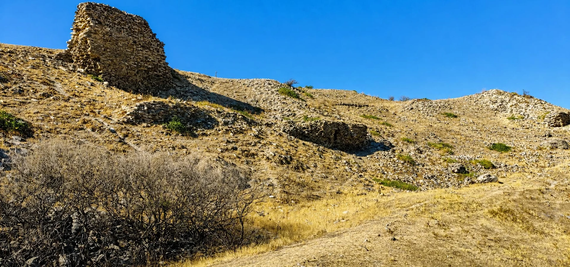
The most historically significant visible remains include the Byzantine defensive walls. Archaeological research identifies several construction phases spanning the early 7th century to the late 13th century AD, demonstrating the settlement's continued military importance.

Other remains indicate the existence of a substantial Roman-period city. These include traces interpreted as a stadium, masonry associated with public or other buildings and architectural fragments scattered across the site.

Defensive Walls

Substantial Byzantine masonry enclosed important parts of the inhabited settlement.

Stadium

Identifiable traces of a Roman athletic structure provide evidence of organized civic activity.

Public Buildings

Scattered foundations and masonry suggest structures whose exact functions are not always established.

Architectural Blocks

Carved and reused stone fragments preserve evidence of ancient building techniques.

Necropolis

Funerary remains and sarcophagus fragments have been reported in the archaeological area.

River Crossing

Archaeological and historical evidence points to an important ancient bridge associated with the city.

Important archaeological distinction: Not every stone alignment can be securely identified as a temple, theatre, residence or public monument. Some structures mentioned in older accounts are difficult to recognize on the ground without specialist guidance.

Byzantine Fortifications of Antiocheia ad Maeandrum

The defensive walls are among the most important archaeological features at Antiocheia. Their scale and multiple building phases reveal the changing military requirements of a settlement that stood near important roads and a major river crossing.

Research has identified four different construction characteristics or phases in the Byzantine fortifications, ranging broadly from the early 7th century to the end of the 13th century. This long period illustrates the city's continued occupation, repair and adaptation during centuries of political instability.

The walls were not simply decorative boundaries. They protected inhabitants, guarded the settlement's elevated position and supported military activity in a region repeatedly affected by conflicts between competing powers.

Different masonry techniques, rebuilt sections and the relationship between the walls and natural slopes help reveal how defenders adapted to the landscape.

Hilltop Position

Elevated terrain strengthened the site's defensive advantages.

Multiple Building Phases

The walls preserve evidence of repeated construction and adaptation.

Frontier Defense

Fortifications gained importance as Byzantine control of Anatolia was challenged.

Strategic Visibility

The settlement overlooked routes and approaches through the surrounding valley.

Conservation reminder: The walls are archaeological remains, not maintained recreational climbing structures. Never climb unstable masonry, enter cavities or disturb loose stones.

The Ancient Stadium of Antiocheia

Among the most interesting remains recorded at Antiocheia is a structure identified as an ancient stadium. Although it is not restored or presented like the better-known stadiums of large archaeological sites, its surviving form is evidence that the city once possessed facilities for public activities and athletic competition.

In the Greek and Roman worlds, stadiums were associated with sporting contests, civic festivals and public gatherings. Such buildings represented more than entertainment: they were part of the social and cultural identity of an ancient city.

The remains at Antiocheia help confirm that this was not merely a small fortified village. During the Roman period, the settlement supported a more extensive urban environment than its present appearance might suggest.

Roman Urban Culture

A stadium indicates participation in forms of public life common across Roman Asia Minor.

Fragmentary Remains

Only parts of the structure can be recognized in the present landscape.

Archaeological Evidence

The building's interpretation is supported by studies of the surviving surface remains.

Unfinished Research

Further archaeological work is needed to establish more details of its construction and use.

The Ancient Bridge and Trade Routes of Antiocheia

One reason for Antiocheia's location was its proximity to an important crossing of the Maiandros River. Ancient travelers, merchants and armies needed dependable routes across western Anatolia, and river crossings could influence the prosperity and security of neighboring settlements.

Researchers associate Antiocheia with a bridge on the road network extending from the Aegean region into the Anatolian interior. The crossing connected the wider Meander Valley with routes toward Caria and the upland regions farther south.

Coins associated with the ancient city have also contributed to discussions of the bridge and its importance. Such evidence helps historians understand how inhabitants represented their city and its geographical identity.

The road through the valley was part of a broader network linking important settlements. Antiocheia's position between the river, the southern roads and fertile farmland helps explain why this particular hill became an urban center.

Regional Commerce

Roads supported the movement of agricultural goods and other merchandise.

River Crossing

A bridge provided a strategically valuable passage across the Meander.

Aphrodisias Connection

Southern routes linked the valley with the territory of the famous Carian city.

Military Movement

Control of the crossing mattered to armies traveling through western Anatolia.

Visiting the bridge area: The ancient bridge and the main hilltop remains should not be assumed to form one easily walkable visitor route. River conditions, land access and the identification of individual remains require local verification.

Antiocheia in Ancient Written Sources and Coins

Because major excavations have been limited, written records and numismatic evidence are particularly important to the study of Antiocheia ad Maeandrum. Ancient authors preserve fragments of its geographical and political history, while coinage provides evidence for the city's identity and civic institutions.

Strabo

The Greek geographer identifies Antiocheia in his discussion of the Meander region and Caria.

Pliny the Elder

His Natural History associates the city with the earlier communities Symmaethos and Cranaos.

Livy

The Roman historian mentions Antiochia on the Maeander while describing events in 189 BC.

Ptolemy

The ancient geographer records the settlement in his description of the region.

Ancient Coins

Civic coinage preserves forms of the city's name and imagery relevant to its history.

Medieval Chronicles

Later accounts illuminate the city's role during Byzantine and Seljuk conflicts.

The combination of literary, archaeological and numismatic evidence is essential because no single source provides a complete history of the settlement.

The Battle of Antiocheia ad Maeandrum in 1211

The event that made Antiocheia particularly important in medieval history was the Battle of Antioch on the Meander, fought in 1211 between the Empire of Nicaea and the Seljuk Sultanate of Rûm.

After the Fourth Crusade captured Constantinople in 1204, Byzantine political authority fragmented. Theodore I Laskaris established his power in the Empire of Nicaea, while the Seljuk state controlled substantial areas of central Anatolia.

The Seljuk Sultan Kaykhusraw I supported the claims of the former Byzantine emperor Alexios III Angelos, creating a direct challenge to Laskaris. The dispute led to military confrontation in western Anatolia.

The fighting near Antiocheia was intense. Although the Nicaean army suffered heavy losses, Theodore I Laskaris emerged victorious. Kaykhusraw I was killed during the battle, and Alexios III was captured.

The Nicaean victory strengthened Theodore's political position and checked the immediate Seljuk threat to his territory. The battle became one of the most significant military encounters between these powers during the early 13th century.

Date

AD 1211, during the early history of the Empire of Nicaea.

Empire of Nicaea

Led by Theodore I Laskaris, a successor ruler of the Byzantine imperial tradition.

Seljuk Sultanate

Led by Sultan Kaykhusraw I, whose forces challenged Nicaean control.

Outcome

A Nicaean victory with heavy losses and the death of the Seljuk sultan.

Political Consequence

The battle reinforced Theodore's authority during a period of imperial instability.

Historical Landscape

The battle is associated with the city's territory rather than a marked modern battlefield park.

Historical context: The precise battlefield should not be confused with a securely identified location among the exposed ruins. Modern visitors are exploring the wider territory associated with the confrontation.

What to See at Antiocheia ad Maeandrum

A visit to Antiocheia is best approached as an exploration of an ancient landscape rather than a conventional walk through a reconstructed archaeological park. The remains are fragmentary, and some features require experience or specialist interpretation to identify confidently.

Byzantine City Walls

Look for surviving defensive masonry and changes in construction methods.

Stadium Remains

Study the landscape associated with the city's ancient athletic structure.

Scattered Stone Blocks

Observe surviving architectural fragments from the settlement's former buildings.

Ancient Building Traces

Examine visible masonry and foundations without assuming that every structure has been identified.

Meander Valley Views

Appreciate the geographical setting that influenced the city's prosperity and defense.

Historic Road Landscape

Consider how the settlement controlled movement through the surrounding valleys.

Set realistic expectations: Do not expect standing colonnades, restored theatres, information panels at every structure or a clearly marked circuit. The appeal of Antiocheia lies in its history, surviving masonry and largely undeveloped setting.

Archaeological Research at Antiocheia

Antiocheia has attracted the attention of travelers and historians since the early modern period, but it remains much less thoroughly investigated than the major archaeological cities of western Türkiye.

Historical travelers described ruins in the area during the 18th and 19th centuries. More recent archaeological surveys documented visible remains and helped clarify the settlement's layout and chronology.

Research including work by Christopher Ratté and colleagues in the 1990s and later studies of the fortifications and urban remains has contributed to the modern understanding of the site.

A study by Rıza Haluk Söner, published in Humanitas in 2017, examines the city's historical geography, surviving remains and military importance. It emphasizes both the value of the existing evidence and the limits imposed by insufficient systematic archaeological investigation.

Many questions remain unanswered, including the detailed street plan, the functions of several large buildings, the development of residential neighborhoods and the full chronology of the ancient urban center.

Surface Surveys

Recorded visible ruins and helped establish the location of major archaeological features.

Epigraphy

Inscriptions contribute evidence about ancient civic identity and history.

Numismatics

Coins provide information about the city, its names and historical connections.

Architectural Study

Masonry analysis helps distinguish different construction phases.

Further reading: Consult the 2017 archaeological study in Humanitas and the official Kuyucak District Governorate's historical description for additional research and background.

Practical Tips for Visiting Antiocheia ad Maeandrum

Visiting Antiocheia requires more preparation than visiting an established archaeological attraction. The site occupies natural terrain, and official visitor facilities and routes are not consistently documented.

Confirm Access

Check locally for current entry permissions, road conditions and any restricted archaeological areas.

Wear Walking Shoes

Expect dry grass, loose stones, uneven ground and potentially steep sections.

Bring Water

Do not rely on finding cafés, drinking water or shops at the ruins.

Use Sun Protection

Parts of the exposed landscape have limited shade during hot weather.

Choose Daylight

Explore only when visibility is good and allow time to return safely.

Use a Suitable Vehicle

A private vehicle is useful for reaching the surrounding rural area.

Respect Farmland

Do not cross cultivated land, gates or private property without permission.

Avoid Disturbing Ruins

Never dig, move archaeological objects or climb unstable structures.

Important safety advice: The site should not be treated as an officially maintained hiking trail. Avoid isolated cavities, unstable walls and overgrown areas where the ground cannot be seen clearly.

Antiocheia ad Maeandrum Visitor Information

Antiocheia ad Maeandrum is located in the countryside of Kuyucak district. Unlike major archaeological parks, it is not consistently presented in official visitor listings with a published ticket office, fixed opening schedule or developed visitor circuit.

As of October 2026, the available local-government and archaeological sources describe the site's location and historical importance but do not establish a reliable public timetable or standard admission price. Therefore, visitors should verify access before setting out.

Because the remains are spread across a rural archaeological landscape, some features may not be safely or legally accessible even when visible from nearby paths.

Ancient City Antiocheia ad Maeandrum (Antiokheia)
Modern Location Başaran–Azizabat area, Kuyucak, Aydın
Historical Region Caria, Meander Valley
Site Type Largely unexcavated ancient urban and fortified settlement
Opening Hours No reliable formal schedule confirmed; check locally
Admission Current ticket and access arrangements require verification
Suggested Time Approximately 1–2 hours on site, conditions permitting
Best For Archaeology, Carian history, Byzantine studies and historical landscapes
Facilities Do not assume toilets, refreshments or maintained visitor paths
Check before traveling: Contact local authorities or consult the Kuyucak District Governorate for the latest information about the archaeological site, suitable access and potential restrictions.

Best Time to Visit Antiocheia ad Maeandrum

Weather and terrain are important considerations because the site is predominantly outdoors and may require walking across exposed, uneven ground.

Spring

Green landscapes and moderate temperatures are particularly attractive for exploration.

Autumn

Comfortable weather and softer light make this another excellent season.

Summer Morning

Visit early to reduce exposure to strong sun and high temperatures.

Winter

Rain can make rural approaches and loose ground muddy or slippery.

Clear Weather

Dry conditions improve visibility and make uneven archaeological terrain easier to navigate.

Daylight Hours

Plan your visit with enough time to return before sunset.

How Long Do You Need at Antiocheia?

30–45 Minutes

A brief look at accessible visible remains, if local entry and approach conditions permit.

1 Hour

A short archaeological visit emphasizing the landscape and principal visible ruins.

1–2 Hours

A more rewarding visit for travelers interested in the history and surviving architecture.

Half-Day Area Visit

Combine the ancient site with a relaxed exploration of Kuyucak and the surrounding valley.

Full-Day Heritage Route

Combine Antiocheia with other archaeological or cultural destinations in eastern Aydın.

Specialist Visit

Allow additional time for historical interpretation, landscape study and photography.

These estimates refer to time spent visiting or exploring accessible parts of the site. Travel, finding an appropriate approach and confirming permission may require additional time.

Photography at Antiocheia ad Maeandrum

Antiocheia offers atmospheric opportunities for landscape and archaeological photography. Instead of monumental restored columns, the visual story lies in ancient masonry, hillsides, agricultural plains and the relationship between ruins and geography.

Ancient Stonework

Photograph weathered blocks, construction details and surviving wall surfaces.

Byzantine Walls

Use wider compositions to show defensive architecture within the natural landscape.

Valley Views

Capture the expansive agricultural plain and surrounding hills.

Morning Light

Low sunlight emphasizes surface textures and creates softer landscape contrasts.

Autumn Atmosphere

Seasonal colors and clear skies can create striking archaeological photographs.

Responsible Photography

Do not move stones, enter unsafe ruins or cross private land to obtain a photograph.

Accessibility at Antiocheia ad Maeandrum

Antiocheia is not comparable to an archaeological park with an established network of paved visitor paths. The ancient remains occupy elevated and sometimes uneven rural terrain.

Uneven Ground

Loose stones, natural slopes, vegetation and rough surfaces may make walking difficult.

Wheelchair Access

No reliable information confirms a continuous accessible route through the ruins.

Limited Mobility

Consider landscape viewpoints or an alternative archaeological site with maintained facilities.

Children

Close supervision is essential around stones, slopes and potentially unstable remains.

Rest Facilities

Plan rest stops in nearby settlements rather than depending on facilities at the site.

Local Guidance

Confirm the safest access points with knowledgeable local contacts before visiting.

How to Get to Antiocheia ad Maeandrum

Antiocheia is located in the Kuyucak district of Aydın, between the areas of Başaran and Azizabat. The ancient city lies approximately 20 kilometers east of Nazilli, near the confluence of the Dandalaz and Büyük Menderes rivers.

The official local description directs travelers from the Aydın–Denizli road toward the Karacasu–Tavas road and through Başaran. Because the site is rural, verify the final approach and any access restrictions rather than relying on a map pin alone.

From Kuyucak

Follow locally confirmed directions toward Başaran and the archaeological hill.

From Nazilli

Travel east toward Kuyucak, then use the appropriate local road toward Başaran.

From Aydın

Use the eastbound Aydın–Denizli corridor toward the Kuyucak district.

From Aphrodisias

Travel north toward the Meander Valley using the regional road network.

Private Vehicle

The most practical option for navigating the rural area and combining nearby sites.

Public Transport

Regional services may reach nearby towns, but do not assume direct transport to the ruins.

Navigation tip: Search for "Antiokheia ad Maeandrum, Kuyucak" rather than simply "Antioch." Several unrelated ancient cities share similar names.

Places to Visit Near Antiocheia ad Maeandrum

The eastern districts of Aydın contain important ancient cities, archaeological museums, Ottoman-era monuments and traditional settlements. Antiocheia can be combined with other destinations according to available time and transport.

Suggested Antiocheia and Meander Valley Heritage Route

For travelers interested in lesser-known archaeology, Antiocheia can form part of a private historical route through the eastern part of Aydın Province. A practical itinerary combines a major excavated city with the quieter landscape of Antiocheia.

Begin at Nysa Ancient City near Sultanhisar to explore a more extensively visible Roman urban center. Continue east through the Meander Valley toward Kuyucak and, if local conditions allow, visit the ruins of Antiocheia ad Maeandrum.

Afterwards, follow the route south toward Karacasu and the archaeological site of Aphrodisias. This allows visitors to compare different types of ancient settlement, from urban monuments to largely unexcavated fortified landscapes.

Start Nysa Ancient City near Sultanhisar
Continue Meander Valley and Kuyucak
Hidden Heritage Antiocheia ad Maeandrum, subject to confirmed access
Local Culture Karacasu and its traditional heritage
Grand Finale Aphrodisias Ancient City and Museum
Transport Private vehicle recommended
Planning recommendation: This is a regional itinerary concept, not a guaranteed timed schedule. Antiocheia access, driving conditions and opening times at other attractions should be checked before confirming the route. Travelers who prefer a relaxed pace may wish to divide these sites between two days.

Frequently Asked Questions About Antiocheia ad Maeandrum

Where is Antiocheia ad Maeandrum?

It is located in Kuyucak district, Aydın Province, between the Başaran and Azizabat areas near the meeting of the Büyük Menderes and Dandalaz rivers.

What is Antiocheia ad Maeandrum?

It is an ancient city of Caria with Hellenistic, Roman and Byzantine history, known for its strategic position, surviving fortifications and association with the Battle of 1211.

What does Antiocheia ad Maeandrum mean?

The name means approximately "Antioch on the Meander," referring to the ancient Maiandros River, today's Büyük Menderes.

Is Antiocheia the same as Antioch in Antakya?

No. Ancient Antioch on the Orontes is in Hatay Province, while Antiocheia ad Maeandrum is in Aydın Province.

Is it the same as Pisidian Antioch?

No. Pisidian Antioch is near Yalvaç in Isparta Province and is an entirely separate ancient settlement.

Who founded Antiocheia ad Maeandrum?

The city's Hellenistic development or renaming is commonly associated with the Seleucid dynasty, possibly Antiochus I Soter. The precise circumstances remain uncertain.

How old is Antiocheia?

Its documented Hellenistic history reaches back more than 2,000 years, while earlier settlement traditions may predate the Seleucid period.

Why was Antiocheia important?

It controlled strategically important road connections, an ancient river crossing and access between the fertile Meander Valley and the Carian interior.

What can visitors see today?

The main archaeological evidence includes Byzantine fortifications, traces of a Roman stadium and scattered remains of ancient structures.

Does Antiocheia have a Roman stadium?

Yes. Archaeological researchers have identified remains interpreted as a stadium, although it is not restored as a formal visitor attraction.

Are there temples at Antiocheia?

Ancient religious activity formed part of the city's history, but individual temple buildings should not be assumed to be securely identified or easily visible at the site today.

Is Antiocheia fully excavated?

No. Archaeological investigation has been limited, and much of the ancient settlement remains unexcavated or incompletely understood.

What happened at Antiocheia in 1211?

The surrounding region was the setting of a major battle between the Empire of Nicaea, led by Theodore I Laskaris, and the Seljuk Sultanate of Rûm, led by Kaykhusraw I.

Who won the Battle of Antiocheia?

The forces of Theodore I Laskaris won the battle in 1211. The Seljuk sultan Kaykhusraw I was killed during the confrontation.

Was Antiocheia an important Byzantine city?

Yes. Its fortifications and strategic position show that it was significant in the military history of the Meander Valley, particularly during the medieval frontier period.

Is Antiocheia ad Maeandrum open to tourists?

Current official opening arrangements are not consistently published. Visitors should confirm whether access is permitted and which areas can be visited before traveling.

Is there an entrance fee?

A reliable current admission price has not been confirmed. Check locally rather than assuming that the absence of a ticket listing guarantees unrestricted entry.

Are there visitor facilities?

Do not expect a developed visitor center, maintained walking circuit, toilets or refreshments at the ruins unless confirmed locally.

How long should I spend at Antiocheia?

Allow approximately one to two hours for a focused visit to accessible remains, with additional time for the rural approach and historical interpretation.

What is the best season to visit?

Spring and autumn are generally most comfortable. Summer visits are better planned for the morning because of heat and limited shade.

Is Antiocheia suitable for children?

Older children interested in history may enjoy the landscape, but the rough terrain, exposed stones and limited facilities require careful supervision.

Is Antiocheia wheelchair accessible?

No continuous wheelchair-accessible visitor route could be confirmed. Uneven rural terrain may create significant obstacles.

Can Antiocheia be combined with Aphrodisias?

Yes. Both belong to the historical landscape of ancient Caria and can be connected by a regional driving itinerary, subject to travel time and site access.

Is Antiocheia ad Maeandrum worth visiting?

For travelers interested in archaeology, lesser-known history and Byzantine frontier settlements, it can be a fascinating destination. Visitors seeking a restored ancient city with extensive facilities may prefer to begin with Nysa or Aphrodisias.

Responsible Visiting at Antiocheia ad Maeandrum

Because Antiocheia remains largely unexcavated, the protection of its archaeological landscape is especially important. Small fragments and unassuming stones may preserve information essential to future research.

Leave Stones in Place

Even a small fragment may be important archaeological evidence.

Never Dig

Do not disturb soil, buried materials or archaeological layers.

Do Not Climb Walls

Weathered masonry may be fragile and potentially dangerous.

Respect Private Land

Obtain permission before crossing agricultural fields, gates or enclosed areas.

Leave No Waste

Carry out all bottles, packaging and other rubbish.

Follow Local Restrictions

Observe archaeological protection rules and any temporary access limitations.

Private Antiocheia & Ancient Caria Experiences

Explore the hidden archaeological landscapes of the Meander Valley with a privately arranged itinerary connecting ancient cities, traditional towns and historic monuments. Visits to Antiocheia are subject to confirmation of local access conditions.

Explore the Forgotten Cities of Caria

Discover the quieter side of western Anatolia through a route tailored to your historical interests.

Continue Exploring Aydın's Archaeological Heritage

Connect the history of Antiocheia with other remarkable monuments and museums of western Türkiye.