Private Arapapıştı Canyon Tour
Travel through the Bozdoğan countryside to Kemer Dam and experience the canyon boat journey, panoramic landscapes and historical features at a comfortable private pace.
Request Your Private Arapapıştı Tour





Arapapıştı Canyon, also known as İnceğiz Canyon, is one of the most spectacular natural landscapes of Aydın Province. Located around the Kemer Dam basin near Bozdoğan, the canyon lies close to the meeting point of Aydın, Denizli and Muğla provinces.
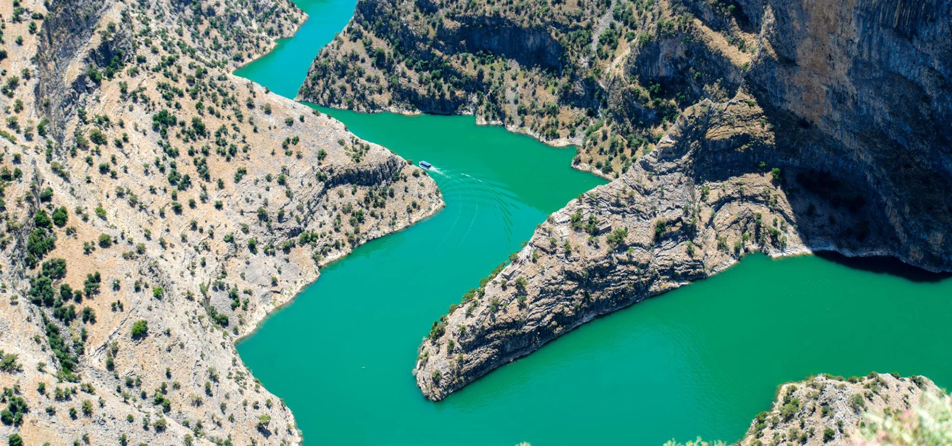
Carved through the landscape by the waters of the Akçay, the canyon extends for approximately 6 kilometres. Its steep rocky walls rise dramatically above the water and in places approach approximately 380 metres in height.
The experience is not limited to scenery. Ancient rock-cut features, caves, settlement traces, a remarkable rock tomb and archaeological remains around the surrounding valleys reveal that people have interacted with this difficult landscape for thousands of years.
Today, one of the most memorable ways to experience Arapapıştı is by boat, travelling across the calm waters of the Kemer Dam reservoir and entering the narrow canyon corridor between towering cliffs.
Travel between monumental canyon walls and experience the scale of Arapapıştı directly from the water.
Look upward toward dramatic rock faces that rise hundreds of metres above sections of the canyon.
Discover a mysterious rock-cut tomb estimated to be approximately 2,500 years old and traditionally associated with the Persian period.
See caves, archaeological traces, rugged mountains and turquoise-green water within a single remarkable landscape.
A practical introduction to one of the most impressive natural attractions in inland Aydın Province.
Kemer Dam and Akçay Valley near Bozdoğan in Aydın Province, close to the borders of Denizli and Muğla.
Open on Google MapsApproximately 6 kilometres through a dramatic landscape of steep rock walls and narrow waterways.
Rock walls reach approximately 380 metres in some sections of the canyon.
Scenic boat journeys, emerald water, narrow passages, high cliffs, caves and ancient remains.
The canyon was shaped by the Akçay, which flows through the landscape associated with Kemer Dam.
Rock-cut remains, caves, settlement traces and a monumental ancient tomb demonstrate a long human connection with the valley.
Arapapıştı combines dramatic geology, water, wildlife and archaeological heritage within a remarkably isolated setting.
The importance of Arapapıştı Canyon lies in the unusual combination of natural and cultural heritage concentrated within a relatively small landscape.
The canyon itself is the result of a long interaction between geological processes and the erosive power of the Akçay. Over immense periods of time, water cut progressively deeper through the surrounding terrain, producing the steep-sided gorge visible today.
In several places, the channel narrows dramatically between almost vertical rock faces. From water level, these cliffs create one of the most impressive landscapes in the inland Aegean region.
Yet this was never simply an empty wilderness. Caves and natural shelters offered protected spaces, while archaeological remains around the canyon demonstrate human activity extending back into antiquity.
The result is a destination where geology, archaeology, photography, boating and nature can all be experienced together.
For travellers exploring the wider region, Arapapıştı represents the natural counterpart to the extraordinary ancient cities introduced in our Aydın travel guide.
The landscape of Arapapıştı was created through an extremely long process involving geological movement, uplift, erosion and the continuous action of water.
The Akçay gradually cut through the resistant rock of the valley as it travelled through the mountainous landscape.
Over time, the watercourse deepened and widened existing weaknesses in the rock, producing the cliffs, bends, narrow channels and protected recesses that characterise the canyon today.
The construction of Kemer Dam later transformed the appearance of the lower landscape. Water now occupies sections of the gorge, creating the calm reservoir environment through which modern sightseeing boats travel.
Water levels therefore influence what visitors can see. Certain caves, rock formations and historical features become more or less visible depending upon reservoir conditions.
The watercourse was the principal natural force responsible for cutting through the canyon landscape.
Long-term erosion exposed towering rock faces that now dominate views from the water.
Some sections contract to approximately 12 metres across, intensifying the feeling of entering a natural corridor.
The modern reservoir transformed the lower canyon into the navigable water landscape experienced by visitors today.
The unusual name Arapapıştı has inspired several local explanations and traditions.
One widely repeated tradition connects the name with Arab incursions into western Anatolia during the Byzantine period, particularly around the 7th century CE.
According to the local story, an invading force moving through the region encountered the enormous canyon and found its passage blocked by the deep gorge.
The name is consequently explained in local tradition as referring to a place where the approaching forces were surprised, confused or unable to continue.
This story should be understood as a traditional explanation rather than a securely documented historical event. Nevertheless, it has become an important part of the cultural identity surrounding the canyon.
The canyon is also known as İnceğiz Canyon, while local sources occasionally use the name Körteke in connection with the surrounding landscape.
The name is traditionally linked with stories concerning early medieval Arab incursions into western Anatolia.
Another widely used geographical name for the canyon, particularly from the Denizli side of the landscape.
The popular explanation survives through regional storytelling rather than through definitive archaeological evidence.
Its position near the meeting point of several provinces has encouraged different local names and approaches to the canyon.
The rugged geography surrounding Arapapıştı has shaped human activity in the region for thousands of years.
During antiquity, this part of inland southwestern Anatolia belonged to a complex cultural landscape connected with Caria and the interior valleys leading toward important settlements such as Aphrodisias.
Although the canyon itself was never a great urban centre, archaeological remains in the surrounding countryside reveal settlements, defensive positions, roads, tombs and places of refuge.
Caves along the rock walls provided natural shelter. Some show indications of human use during different periods, while other protected spaces have been interpreted as places of retreat or refuge.
Among the most intriguing discoveries is a monumental rock-cut tomb on the canyon wall, estimated to date back approximately 2,500 years and generally associated in local archaeological interpretation with the Persian period.
Roman and Byzantine settlement traces also survive around the wider valley, demonstrating that the isolated appearance of the modern canyon hides a much longer history of movement and occupation.
The canyon formed part of a wider historical landscape occupied by communities across inland southwestern Anatolia.
A monumental rock tomb within the canyon is generally believed to date to approximately the 6th–5th centuries BCE.
Settlement remains around the valley demonstrate continued occupation during the Roman period.
Protected caves and secluded locations may have been reused as refuges or places of religious withdrawal.
One of the most remarkable archaeological features within the canyon landscape is an ancient rock-cut tomb constructed into the cliff face.
Local archaeological and tourism sources date the monument to approximately 2,500 years ago and generally associate it with the period of Persian influence in western Anatolia.
Its relatively monumental character has encouraged the interpretation that it may have belonged to an individual of high political or military status.
The tomb demonstrates that the canyon was not simply a natural barrier. Its cliffs formed part of a cultural landscape in which prominent locations could acquire funerary, symbolic and territorial significance.
Visibility of the monument can change according to reservoir water levels. During periods of higher water, portions of historical features close to the shoreline may become more difficult to observe.
The cliffs of Arapapıştı contain numerous caves, cavities and protected recesses created by natural geological processes.
Some occur close together and are traditionally known as the Sıra İnler, meaning a sequence or row of caves.
These protected spaces attracted human activity during different periods because they offered shelter from weather, visibility and the difficult surrounding terrain.
When reservoir levels are sufficiently low, additional openings and rock formations can become visible from the water.
Some larger recesses may be approached during boat journeys when conditions permit, although actual access depends upon water level, safety rules and the route selected by the boat operator.
A series of neighbouring cave openings that form one of the canyon's distinctive historical landscape features.
Rock cavities provided protected spaces within an otherwise steep and difficult environment.
The appearance of lower caves varies considerably according to reservoir water levels.
Several caves are believed to have been used or adapted by people during different historical periods.
For most visitors, a boat journey is the best way to experience the scale and atmosphere of Arapapıştı Canyon.
The journey begins across the wider waters associated with Kemer Dam before entering increasingly dramatic sections of the gorge.
As the route narrows, high rock walls rise above the boat and the surrounding landscape becomes progressively more enclosed.
Official tourism information commonly describes canyon boat trips lasting approximately 1.5 to 2 hours, although the actual duration can change according to water level, operating conditions and the route used on the day.
From the boat, visitors may see caves, unusual geological formations and historical features that are difficult or impossible to appreciate from the surrounding roads.
Because reservoir conditions change throughout the year, every journey can reveal a slightly different version of the canyon.
The visitor experience at Arapapıştı is closely connected with Kemer Dam and its reservoir.
The Akçay flows through the surrounding mountain landscape and contributes water to the reservoir, creating the broad green-blue surface encountered before boats enter the narrower gorge.
The reservoir dramatically changed the modern appearance of sections of the valley, flooding lower areas and creating navigable water around archaeological and geological formations.
For this reason, the water level plays an unusually important role in the appearance of Arapapıştı.
During lower-water periods, structures and rock formations close to the former river level may become easier to see. During higher-water periods, the canyon can appear deeper and more enclosed.
The river system that shaped the canyon and supplies the wider Kemer Dam landscape.
Calm reservoir water makes scenic boat exploration of the canyon possible.
Seasonal and operational changes in water level alter the visibility of caves and historical features.
The reservoir is surrounded by rugged hills that create expansive views beyond the narrow canyon itself.
The historical landscape of Arapapıştı extends beyond the water itself.
Near Körteke, archaeological remains occupy the hill traditionally known as Kale Tepe.
The site is associated with the remains of an ancient settlement generally identified as Xyatis, connected with the cultural landscape of ancient Caria.
Fortified positions in this mountainous region offered commanding views across valleys and routes, making elevated locations particularly valuable for controlling movement through the interior.
Later Roman and Byzantine activity in the wider region demonstrates that these valleys continued to retain strategic and agricultural importance for many centuries.
A fortified archaeological landscape positioned in the hills surrounding Arapapıştı Canyon.
Ancient settlement remains associated with the Carian cultural landscape survive around Kale Tepe.
Elevated terrain provided wide views across approaches to the surrounding valleys.
The area contains evidence from several historical periods rather than representing a single isolated settlement.
Another historical feature associated with the wider canyon landscape is the Kemer Bridge.
Depending upon the water level of the reservoir, parts of the historic crossing may become more visible within the landscape.
Regional tourism traditions sometimes associate the bridge with the campaigns or armies of Alexander the Great.
This attribution is repeated in tourism literature, but visitors should treat it cautiously rather than assuming that a direct connection with Alexander has been conclusively established archaeologically.
Regardless of its precise chronology, the crossing illustrates an important point: the valleys around Arapapıştı were not isolated wildernesses but part of networks connecting settlements across inland Caria and the Aegean hinterland.
The bridge belongs to the wider network of routes that once connected communities across the interior.
Reservoir levels influence how much of the historic structure can be observed.
Mountain valleys provided important corridors linking settlements, agricultural areas and regional centres.
Stories connecting the bridge with Alexander the Great remain part of regional tourism tradition but should be treated cautiously.
The combination of open water, cliffs, woodland, agricultural valleys and relatively quiet mountain terrain creates varied habitats around Arapapıştı.
Birds are particularly noticeable from the water. Herons and cormorants may be encountered around the reservoir and canyon, while storks are also associated with the wider Akçay Valley.
Vegetation changes according to elevation and exposure. Rocky cliff faces support relatively sparse growth, while sheltered valleys and slopes contain a richer mixture of Mediterranean and inland Aegean vegetation.
Olive, fig and agricultural landscapes appear around settlements beyond the canyon, contrasting strongly with the almost vertical rock environment encountered from the boat.
The quietest journeys can therefore feel as much like a nature excursion as a sightseeing cruise.
These waterside birds may be observed around quieter edges of the reservoir and canyon environment.
Cormorants are among the bird species associated with the canyon's aquatic landscape.
The wider Akçay Valley is known locally for the presence of storks during suitable seasons.
Rocky slopes, trees, shrubs and agricultural land create varied habitats around the water.
Enter the most enclosed sections where immense cliffs rise immediately above the water.
Experience the canyon from water level and appreciate a scale impossible to understand from photographs alone.
Look for the monumental rock-cut burial traditionally dated to approximately 2,500 years ago.
See natural cave openings and shelters scattered along sections of the canyon wall.
Changing light can transform the reservoir from deep green to vivid blue-green tones.
When reservoir levels allow, look for evidence of the historic route that once crossed the valley.
Explore the wider historical environment associated with Körteke Castle and ancient settlement remains.
Higher ground around the region provides a completely different perspective over the winding waterway.
Observe folded, fractured and weathered surfaces created by geological processes over immense periods of time.
Watch for herons, cormorants and other birds moving between water, cliffs and shoreline vegetation.
Arapapıştı is best treated as a half-day nature excursion rather than a short roadside viewpoint.
Travellers planning a boat trip should allow enough flexibility for arrival, parking, ticketing or departure arrangements and possible waiting time before the boat leaves.
Begin by arriving in the Kemer Dam area early enough to confirm the day's boat departures before exploring the surrounding viewpoints.
Take a few minutes to appreciate the broad reservoir first. This open landscape creates an important contrast with the narrow canyon ahead.
Continue with the boat journey, gradually entering the steep-sided gorge and watching for caves, cliff formations and the ancient rock tomb.
As the channel narrows, concentrate on the relationship between water and rock. The enormous vertical scale is the defining experience of Arapapıştı.
After returning from the boat journey, allow time for photography and viewpoints around the reservoir.
Travellers with a full day can then continue through the Bozdoğan countryside or combine the canyon with carefully selected historical sites in inland Aydın.
Kemer Dam landscape and orientation before the boat journey.
Boat departure and the broad reservoir landscape.
Narrow Arapapıştı Canyon and its towering cliff walls.
Rock tomb, caves and historical features visible along the water route.
Return across the reservoir and stop for panoramic photography.
Continue through Bozdoğan or toward another destination in inland Aydın.
Aydın is often associated with ancient cities and the Aegean coast, yet the province also contains extraordinary inland mountain and river landscapes.
Arapapıştı reveals this very different side of the region.
The natural landscape — famous for steep cliffs, boat journeys, caves and turquoise-green water.
The city of Aphrodite — internationally celebrated for sculpture, architecture and one of Türkiye's finest archaeological landscapes.
The ravine city — famous for its Roman library, theatre, bridges, stadium and extraordinary urban engineering.
The monumental ancient city overlooking the Büyük Menderes Valley immediately above modern Aydın.
A beautifully preserved Greek city whose organised urban plan occupies a dramatic mountainside position.
Two great archaeological destinations revealing the maritime, intellectual and religious history of the ancient Aegean.
Continue exploring with our Aydın travel guide, Aphrodisias Ancient City guide, Nysa Ancient City guide, Tralleis Ancient City guide, Priene Ancient City guide, Miletus Ancient City guide and Didyma & Didymaion guide.
Arapapıştı changes considerably with the seasons, making the experience different throughout the year.
One of the most attractive seasons, with greener hillsides, comfortable temperatures and an especially fresh landscape.
Long daylight and generally settled weather create excellent conditions for boating and photography.
Expect strong sun and high temperatures. Morning departures are usually more comfortable for combining the boat trip with outdoor exploration.
Pleasant temperatures can make autumn particularly enjoyable for combining the canyon with archaeological destinations.
The landscape can be atmospheric and quiet, but weather and water conditions may affect boat operations.
Reservoir conditions change what can be seen along the cliffs, caves and historical shoreline.
Arapapıştı is one of the most visually distinctive natural destinations in Aydın Province.
From the boat, the strongest compositions often combine the dark water with immense rock walls disappearing upward beyond the frame.
The narrowing channel creates natural leading lines, while bends in the canyon constantly reveal new combinations of light, shadow and reflection.
Higher viewpoints provide an entirely different perspective, showing the water winding through an almost abstract pattern of rocky ridges.
Morning and later-afternoon light can give greater texture to the cliff faces, while midday sunlight can intensify the green and turquoise tones of the water.
Use the boat and its wake to provide scale against the immense canyon walls.
Vertical compositions emphasise the extraordinary height of cliffs rising directly from the water.
High viewpoints reveal the serpentine geometry of the canyon and reservoir landscape.
Include surrounding cliff surfaces to communicate the isolated position of the ancient monument.
Calmer water can produce strong reflected patterns of rock, sky and vegetation.
Different times of day dramatically alter the colour of the water and texture of the canyon walls.
The principal canyon experience takes place by boat, but visitors should remember that Arapapıştı remains a natural mountain environment rather than a fully urbanised attraction.
Boarding may require stepping between a dock or shoreline and the vessel. Conditions can change with water level.
Follow all instructions from the boat crew and use safety equipment as directed.
Approach roads pass through rural and mountainous terrain, so allow extra time rather than planning a rushed journey.
Sun protection, drinking water and suitable clothing are important during the hotter months.
Exercise great care near unprotected cliff edges, steep slopes and rocky surfaces.
Travellers with mobility requirements should confirm boarding conditions and current facilities before travelling.
Arapapıştı Canyon is located in the Bozdoğan area of Aydın Province, around the Kemer Dam reservoir and close to the provincial borders with Denizli and Muğla.
Because the canyon lies within a rural mountain landscape, private transportation is normally the easiest way to reach the departure area and coordinate a visit with the boat schedule.
Continue from the district centre toward Kemer and the Kemer Dam landscape following local road signs toward Arapapıştı Canyon.
Travel east through the Büyük Menderes Valley before turning south through the Bozdoğan region toward Kemer Dam.
Nazilli provides one of the principal approaches into the Bozdoğan countryside and the mountain roads leading toward the canyon.
Travellers exploring inland Aydın can connect the Karacasu archaeological landscape with the canyon as part of a carefully planned private route.
The canyon can be considered as part of a longer private journey through the inland landscapes between Denizli and Aydın.
A private vehicle is especially useful when coordinating the boat departure with viewpoints, archaeological sites and other destinations.
Explore the rural landscapes and local life of the district that forms the principal Aydın gateway to Arapapıştı.
Enjoy broad reservoir and mountain views surrounding the entrance to the canyon landscape.
Discover archaeological remains associated with the fortified hill and the ancient settlement traditionally identified as Xyatis.
Experience another side of Bozdoğan through highland scenery, forests and cooler mountain landscapes.
Continue through inland Aydın with our Aphrodisias Ancient City guide.
Explore one of the region's most remarkable Roman cities with our Nysa Ancient City guide.
Discover the ancient city overlooking modern Aydın with our Tralleis Ancient City guide.
Plan a wider journey through the province with our Aydın travel guide.
Arapapıştı Canyon is located around Kemer Dam near Bozdoğan in Aydın Province, close to the meeting point of Aydın, Denizli and Muğla.
The principal canyon is approximately 6 kilometres long.
The canyon walls reach approximately 380 metres in some sections.
Local sources describe sections where the water corridor narrows to approximately 12 metres across.
The canyon was formed by the erosive action of the Akçay, which flows through the wider Kemer Dam landscape.
Yes. Scenic boat journeys are the principal visitor experience and allow travellers to enter the canyon directly from the reservoir.
Sightseeing journeys are commonly described as lasting approximately 1.5 to 2 hours, although the exact duration can vary.
Operations can change according to season, weather, water level and local scheduling. Confirm current departures before travelling.
It is famous for its turquoise-green water, towering cliffs, narrow passages, boat journeys, caves and archaeological remains.
Yes. A monumental rock-cut tomb estimated to be approximately 2,500 years old survives within the canyon landscape and is generally associated with the Persian period.
The identity is unknown. Its monumental character suggests a high-status individual, but specific claims about the occupant remain interpretations rather than established fact.
Yes. Numerous natural cavities occur along the cliffs, including a group traditionally known as the Sıra İnler caves.
İnceğiz Canyon is another name used for Arapapıştı Canyon, particularly in references connected with the Denizli side of the landscape.
Local tradition connects the name with Arab incursions during the Byzantine period and a story in which approaching forces were stopped or surprised by the enormous canyon. This should be treated as traditional folklore rather than proven history.
Visibility depends partly on the water level of the reservoir. Lower-water conditions can reveal more historical features around the former valley floor.
Regional tourism sources traditionally associate the bridge with Alexander's armies, but this connection should be treated as a historical attribution rather than securely established archaeological fact.
Körteke Castle is an archaeological and fortified landscape near the canyon associated with remains of the ancient settlement generally identified as Xyatis.
Spring, early summer and autumn generally offer particularly attractive conditions, although water levels and boat operations should always be checked before travelling.
Yes. The combination of green-blue water, steep cliffs, boats, caves and dramatic aerial viewpoints makes it one of the most photogenic natural landscapes in Aydın.
Allow approximately half a day if you plan to take the boat journey comfortably and spend additional time at viewpoints around Kemer Dam.
Yes, depending on your starting point, season and boat schedule. A private itinerary can combine the canyon with other destinations in inland Aydın, although sufficient travelling time should be allowed.
The regular sightseeing boat experience can be suitable for families, but parents should confirm current operator rules and follow all life-jacket and safety instructions.
Suitability depends especially on current boat boarding arrangements. Travellers with mobility requirements should confirm access conditions before making the journey.
Private transportation is the most practical option because the canyon lies within a rural mountain landscape and boat schedules may require careful timing.
Never leave waste in the reservoir, canyon or surrounding picnic areas.
Do not touch, climb, enter or remove material from tombs, caves, walls or archaeological remains.
Remain seated or move only as directed and follow all safety instructions provided by the crew.
Avoid disturbing birds and other animals, particularly around nesting or resting areas.
Do not approach unstable cliff edges or leave safe areas for photographs.
Take all litter with you and help preserve the quiet natural character that makes Arapapıştı special.
Discover Arapapıştı with comfortable private transportation and an itinerary designed around the canyon boat journey, landscape photography, local history and the archaeological heritage of inland Aydın, without compulsory shopping stops.
Combine the canyon with Bozdoğan, panoramic viewpoints, rural landscapes or carefully selected archaeological destinations according to your available time and travel route.
Travel through the Bozdoğan countryside to Kemer Dam and experience the canyon boat journey, panoramic landscapes and historical features at a comfortable private pace.
Request Your Private Arapapıştı Tour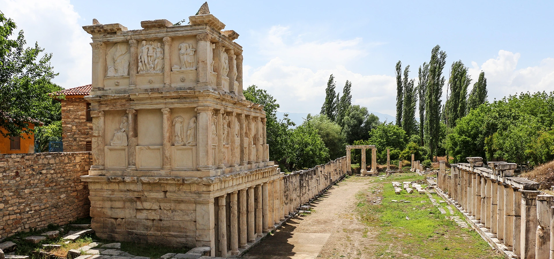
Create a longer private route combining Arapapıştı Canyon with selected archaeological and cultural destinations across inland Aydın according to season, boat schedules and your preferred pace.
Design Your Private Aydın Journey